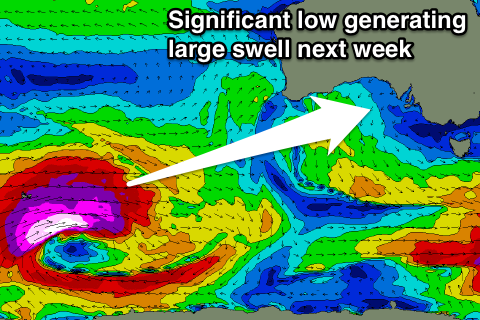
Excellent swell Friday, another large powerful swell next week
South Australian Forecast by Craig Brokensha (issued Wednesday 7th June)
Best Days: Mid Coast later tomorrow, Friday, both coasts Saturday, South Coast Sunday through most of next week
Recap
Great waves across the Mid Coast yesterday with 2ft+ of W/SW swell holding all day with favourable winds.
Today the swell was still hanging in at 1-2ft on the sets across the Mid Coast, 1-1.5ft at most other breaks with straight offshore winds, while the South Coast saw improving conditions and easing waves from 3-4ft off Middleton.
This week and weekend (Jun 8 – 11)
The surf will continue to ease into tomorrow morning across both coasts and you'll have to brave the cold early down South as a dawn NW'ly will give into a S/SW change mid-morning.
Into the late afternoon the Mid Coast should start to see some new W/SW groundswell, generated by a strong polar frontal progression through the Indian Ocean and under WA, with the front linked to this swell bringing tomorrow's change as it passes under us.
We may see 1-1.5ft sets late with S'ly winds, but Friday is the day to surf.
Satellite observations have confirmed a great fetch of severe-gale to storm-force W/SW winds being projected through our western swell window and with this we should see the Mid Coast coming in at consistent 2-3ft from late morning, with Middleton due to kick to 3-5ft into the afternoon.
Unfortunately winds will be poor and fresh from the S/SE across the South Coast, but the Mid Coast should be good all day.
Over the weekend we'll see the W/SW swell ease, slowed across the South Coast but reinforcing SW swell energy from pre-frontal W/NW fetches swinging in from the Indian Ocean, under the country.
Winds will improve for the South Coast but conditions are still likely to be a little peaky Saturday with a morning E/NE-NE breeze. Middleton should ease from 3-4ft, with easing 2ft sets on the Mid Coast.
Sunday looks cleaner with a morning N/NE breeze, variable into the afternoon.
 Into early next week some very inconsistent long-range W/SW groundswell is due to build Monday afternoon, easing Tuesday. This was generated in our far western swell window, south-east of South Africa and the wait between sets are due to be 10-15 minutes. Middleton should see 2ft to sometimes 3ft waves later Monday and early Tuesday, but of greater importance is a large and powerful mix of SW and W/SW groundswell due Wednesday/Thursday.
During this weekend a very significant storm is forecast to form in the Heard Island region (possibly reaching the specifications of a 'bombing low'), with a broad fetch of severe-gale W/SW winds generated with stronger core winds in the storm to hurricane-force range.
This low will project slowly east through our south-western swell window before weakening, only to spawn a secondary strong and more northern front. This will project a secondary broad fetch of severe-gale W/SW winds through our western swell window, with both swell events due to peak concurrently on Thursday morning.
The first super long-period SW groundswell is due to arrive through Wednesday though, building into the afternoon ahead of a peak Thursday.
We'll discuss the sizes in more detail on Friday but winds are looking excellent with N/NE offshores, but check back in a couple of days for the latest on this.


Comments
Is this the one thats about to smash south africa??
Nah, different.
Let me clarify. This low does evolve from the same storm that's currently hitting South Africa , but they are different swells.
See some are forecasting 11m at 22sec over there
11m @17s for Capetown !
Is that true ?
https://www.windguru.cz/91
Barley, as craig said its a bit separate a storm .
Looking at stormsurf wam i think you could just about call it the same storm . Good spotting i hadnt noticed that thanks