Poor outlook with a small window Saturday morning
South Australian Forecast by Craig Brokensha (issued Wednesday 1st March)
Best Days: Saturday mid-late morning on the South Coast
Recap
Flat conditions on the Mid yesterday ahead of a tiny kick in new swell to 0.5ft, hanging in at a similar size this morning.
The South Coast saw clean conditions most of the day, with a good but inconsistent increase in swell through the afternoon. Today the swell was a touch smaller but clean and glassy with light morning offshore winds.
This week and weekend (Mar 2 – 5)
The swell yesterday afternoon and this morning will continue to ease into tomorrow, leaving small 1-1.5ft leftovers across the South Coast at Middleton, tiny to flat on the Mid.
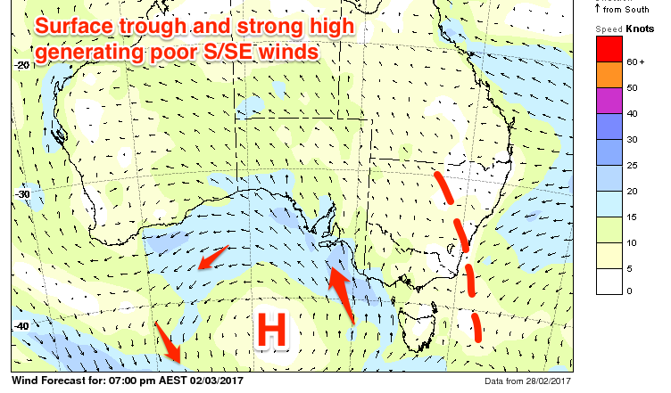
A gusty S/SE change will create terrible conditions as well as kicking up some new S/SE windswell through the day, persisting Friday through Monday, ebbing and pulsing as a surface trough off the East Coast squeezes a strong high to our south.
 Size wise is looks to hang between a junky 2-3ft across most of the coast, with fresh morning SE winds Friday, possibly tending lighter E'ly and even E/NE on Saturday.
This will be when a new S/SW groundswell peaks, generated by a strong polar low forming late in our southern swell window.
This low, forming today will generate a fetch of gale to severe-gale W'ly winds just on the edge of our swell window, with the swell arriving Friday afternoon, peaking Saturday morning to 3ft at Middleton, a bit bigger at Waits and Parsons.
Sunday will be smaller with the S/SE windswell under fresh and gusty S/SE winds.
Next week onwards (Mar 6 onwards)
We'll continue to see average conditions early to mid-next week and junky levels of S/SE windswell owing to a deeper low forming off the East Coast early next week, directing persistent E/SE-SE winds across the state.
The pattern doesn't look to break down until possibly early the following week, but more on this Friday.

