Large swell building tomorrow, cleaner and easing Sunday
South Australian Forecast by Craig Brokensha (issued Friday 13th January)
Sign up to Swellnet’s newsletter and receive the South Australian Forecaster Notes and latest news sent directly to your inbox. Upon signup you'll also enter the draw to win a surf trip to P-Pass for you and a mate (there's only 2 weeks left to go). It doesn’t get much easier so click HERE to sign up now.
Best Days: Keen surfers Mid Coast Saturday afternoon, both coasts Sunday and Monday, Mid Coast Wednesday
Recap
Tiny levels of W/SW swell hung in around 1-1.5ft yesterday morning on the Mid Coast with clean conditions, while the South Coast saw good clean 3ft waves off Middleton most of the day ahead of mid-afternoon sea breezes.
Today the Mid was tiny, while the South Coast saw clean good conditions again with a light offshore wind ahead of an approaching change.
This weekend and next week (Jan 14 - 20)
The approaching change which will hit by the time you read this is linked to an intense low pressure system moving through the Bight.
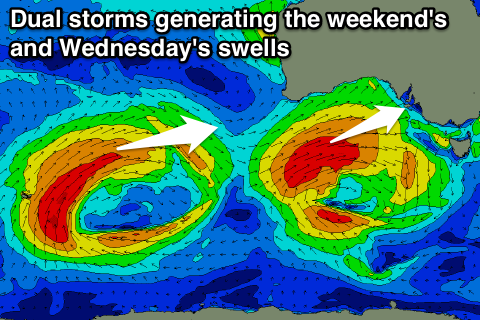
This low, which formed in the southern Indian Ocean has already produced a large W/SW groundswell for WA today, but we'll continue to see a fetch of W/SW gales aimed through our western swell window today, reaching severe-gale through our south-western swell window under us this evening and early tomorrow.
 One final fetch of severe-gale S/SW winds wrapping around the backside of the low as it pushes towards Tasmania will also be generated, moving out of our swell window Saturday afternoon.
A large and powerful W/SW groundswell will result, building rapidly tomorrow from 2ft+ to 3-4ft into the afternoon with a slight push of the tide.
The South Coast is expected to come in around 3-4ft through the morning at Middleton, pulsing to a large 5-6ft into the mid-late afternoon.
A drop in swell is due Sunday out of the SW across both coasts, dropping from 2-3ft on the Mid Coast and 4-5ft down at Middleton, but the S/SW groundswell should arrive into the afternoon down South, keeping similar sized sets into the afternoon, easing Monday from 3-4ft. The Mid Coast should be much smaller Monday and dropping from 1-1.5ft.
Now, winds tomorrow will be average in the wake of today's change with a fresh and gusty SW'ly (likely W/SW early around Victor at dawn), easing through the afternoon and tending more S/SW and possibly S/SE on dark on the Mid Coast.
Sunday looks excellent on the Mid with an offshore E/SE wind and the South Coast will be OK but not great with a light E'ly breeze.
Monday is the pick down South with an offshore N/NE, tending variable through the afternoon ahead of mid-late afternoon sea breezes.
Small surf is due Tuesday with a morning offshore down South ahead of a change, while into Wednesday a new acute but inconsistent W/SW swell is due across the Mid.
This is being generated by a broad and slow moving low in the south-east Indian Ocean, producing a fetch of strong to gale-force W/SW winds in our far swell window.
This swell will be best for the Mid and only small down South, with a late kick Tuesday possibly to 1-2ft, peaking Wednesday around 2ft on the favourable parts of the tide, if not for the odd sneaker. SE-S/SE winds will create good conditions on the Mid, while kicking up a poor quality windswell down South.
More on this Monday, have a great weekend!


Comments
Nice 2-3ft sets at The Hump this morning.
Showing the size a little better.