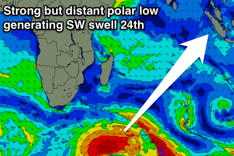
Slow ahead of more action from the 24th
Nias, Mentawai, South Sumatra forecast by Craig Brokensha (issued Thursday 13th August)
Best Days: Every day over the coming period, exposed spots tomorrow through Sunday before SE winds pick up
This week and next week (Aug 14 – 21)
Our good pulse of S/SW groundswell at the start of the week has eased back the last couple of days and S/SE trade-swell has also been in the mix, with it expected to continue through tomorrow as winds tend variable and then ease off into the weekend.
Into next week only small to moderate and inconsistent levels of background S/SW and SW groundswell energy are due to 4-5ft max across exposed breaks, biggest Monday afternoon, Thursday and Friday morning.
 Winds are due to pick up again from the S/SE Monday and Tuesday remaining light to moderate through Wednesday and Thursday before freshening again late week.
From Monday the 24th we're due to see some better swell activity as a series of stronger polar fronts fire up from below South Africa and push east-northeast through the Indian Ocean.
The first due Monday should come in the 6ft+ range, with a secondary similar sized pulse for the 28th. We'll have a closer look at this on Tuesday though.
16 day Mentawai forecast graph
16 day Nias forecast graph
16 day South Sumatra forecast graph


Comments
on thursday friday sat next week how big do you think it will be in telos cheers i am going there
Exposed breaks, as explained above " inconsistent levels of background S/SW and SW groundswell energy are due to 4-5ft max across exposed breaks, biggest Monday afternoon, Thursday and Friday morning." Prob 3-4ft+ Saturday.
Smaller the further you shelter from the swell.
thx guys the report that you give does that cover telos and say macaronis you get same size swell there or is it better to gauge telos latitude zero site from nias
Probably best taking the middle between the Ments and Nias forecasts. Mentawai point is off Macaronis.