Slow week, mix of S/SW and S/SE swells next week
Nias, Mentawai, South Sumatra forecast by Craig Brokensha (issued Tuesday 4th August)
Best Days: Exposed spots over the coming days before winds freshen from the SE early next week
This week and next week (Aug 5 – 14)
Late last week and the weekend offered some better size across the region, but since then, the swell's dropped away again. This week and the coming period there's nothing major due with background pulses of swell due to keep exposed breaks around the 3ft to occasionally 5ft range with weak SE winds, freshening into early next week.
Some stronger S/SW groundswell is due next week, generated by a strong and slow moving polar frontal progression firing up south-east of South Africa today, and pushing east through the rest of the week.
 This should generate an inconsistent but good S/SW groundswell for later Monday but more so Tuesday to an infrequent 5-6ft, easing back through Wednesday and Thursday.
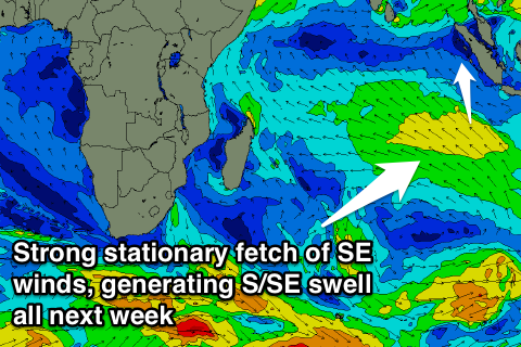
Fresher SE winds will limit surfing options though to protected breaks. These SE winds will be associated with a strengthening and stationary high pressure ridge to our south, with a fetch of strong and persistent SE winds setting in motion a large SE groundswell for the Maldives next week.
This swell should spread out radially up towards us through next week, with exposed spots around the Ments due to see 3-4ft+ sets for most of the week before easing back from next weekend.
Unfortunately locations picking up this swell will see less favourable SE winds.
Longer term there's still nothing significant showing on the charts, but we'll review this Thursday.
16 day Mentawai forecast graph
16 day Nias forecast graph
16 day South Sumatra forecast graph


Comments
I'm still blown away by the lack of swell in the Indian Ocean in July and now into August. Not happy given I'm gonna be up there for the last two weeks of August. Shoulda booked the Maldives instead!!!