Smaller surf into the end of the week
Eastern Tasmanian forecast by Craig Brokensha (issued Wednesday January 22nd)
Best Days: Tomorrow morning (south magnets afternoon), south magnets Friday morning, Monday evening
Features of the Forecast (tl;dr)
- Easing E/NE swell tomorrow, mixed with a new mid-period S'ly swell
- Variable offshore tending N/NE winds tomorrow
- Small, fading S swell Fri with fresh NW tending variable winds
- Small N/NE windswell building Mon with strengthening N/NW winds
Recap
Our first pulse of E/SE swell held in well yesterday morning with clean conditions and 3ft surf across open beaches ahead of sea breezes.
Today our secondary pulse of E/NE swell was a good 3-4ft this morning with early workable winds but they quickly strengthened from the south, limiting the best waves to southern corners.

Early bird catches the worm this morning
This week and weekend (Jan 23 - 26)
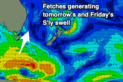
The current E/NE swell will back off through tomorrow from a smaller 2ft+ across open beaches, while a small pulse of S’ly swell from today’s change will also fade, replaced by a better mid-period S’ly swell.

This mid-period swell is being generated by strong SW winds around a broad low that’s moving under us today and should offer 2-3ft sets on the south magnets with light, variable winds ahead of N/NE sea breezes.
Friday should still be 2ft on the south magnets but easing under fresh NW tending variable winds.
We’ve then got tiny surf due into the weekend, with no real notable swells apart from a weak N/NE windswell Monday afternoon.
A strong low moving under us early next week looks too zonal to generate any real size but we’ll review this Friday.

