Fun levels of east swell early-mid next week
Eastern Tasmanian forecast by Craig Brokensha (issued Friday January 17th)
Best Days: Monday, Tuesday, Wednesday in protected spots
Features of the Forecast (tl;dr)
- Small SE swell tomorrow with fresh SE tending E/SE winds
- Slightly stronger E/SE swell Sun with N/NW tending fresh N/NE winds
- Moderate sized E/SE swell Mon with W tending fresh N/NE winds
- Easing swell Tue with W tending fresh N/NE winds
- Late pulse of E'ly swell Tue, peaking Wed with moderate S/SW tending strong S/SE winds
- Easing E swell Thu with SE tending NE winds
Recap
The E/SE swell provided good 2ft to occasionally 3ft sets across open beaches with favourable winds yesterday morning, slower into the afternoon and then a leftover 1-2ft this morning.
This weekend and next week (Jan 18 - 24)
Looking at the current synoptic setup and we’ve got a trough moving up past us, with a weak increase in S/SE windswell this afternoon due to shift more SE tomorrow but only likely to come in at 2ft and with fresh SE tending E/SE winds, lighter to the south early.

Sunday looks similar in size but more out of the E/SE with 2ft+ waves due across open beaches under a N/NW tending stronger N/NE breeze.
Come Monday we should see some bigger, better E/SE swell energy in the water thanks to a broad low taking formation in the southern Tasman Sea, with a fetch of strong SE winds due to be projected towards us tomorrow evening and Sunday.
This fetch looks a little weaker than forecast on Wednesday and with this a bit less size is due Monday, likely coming in at 4ft with the rare bigger one, easing Tuesday from 3-4ft.
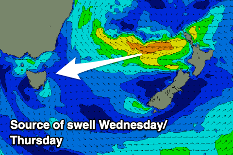
The reinforcing E’ly swell for later Tuesday looks to now be a touch weaker as well thanks to the swell generating fetch off New Zealand coming in mostly below gale-force in strength.

This will put the arrival time on dark Tuesday with Wednesday morning looking to be a better chance to surf with a renewal of 4ft surf before easing through the day.
Looking at the local winds and a W’ly offshore is now due on Monday ahead of fresh N/NE sea breezes, similar Tuesday and then moderate S/SW tending strong S/SE into Wednesday as a trough moves up past us.
This trough may bring some small windswell for the afternoon and Thursday morning with easing levels of E’ly swell from a better 2-3ft.
Longer term the outlook is slower into next weekend so make the most of the coming waves early next week. Have a great weekend!

