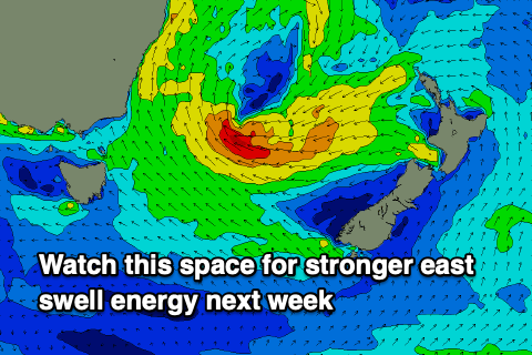
Dynamic, sizey period likely
Eastern Tasmanian forecast by Craig Brokensha (issued Monday January 13th)
Best Days: Today, later Wednesday, Thursday morning, next week
Features of the Forecast (tl;dr)
- Easing NE windswell tomorrow with moderate S-S/SE tending fresher SE winds
- Building NE windswell Wed PM with strengthening NE tending N/NW winds
- Small, inconsistent E/SE swell Wed PM and Thu AM
- Easing NE windswell Thu AM
- Strong S/SW tending SE winds Thu
- Small S swell Fri
- Building S/SE-SE swell Sat with SE winds, likely bigger from Sun and more so next week out of the E
Recap
NE windswell padded out the magnets over the weekend, with windows of lighter winds at times between the onshore chop.
Today the swell generating trough has moved away from us resulting in a drop in swell but cleaner conditions with 2ft waves left across the north magnets.
This week and weekend (Jan 14 - 19)
The current north-east windswell will continue to ease in size through tomorrow but we should still see the odd 1-2ft set across the north magnets with S-S/SE tending SE winds.
We’ve then got another episode of building NE windswell as a trough moves in from the west through Wednesday, bringing strong NE winds and a quick jump in size through the afternoon to 2-3ft across north-east magnets.
Strengthening NE winds are due to shift N/NW into the evening so keep an eye on the late session for wave.
An overnight S/SW change once the trough moves through will bring a rapid drop in NE swell on Thursday down from 1-2ft. There’s also due to be some long-range SE swell from a low that’s formed south-east of New Zealand, but the size doesn’t look to top 2ft to possibly 3ft later Wednesday and Thursday morning.

Morning S/SW winds are due to shift SE on Thursday, smaller Friday as a broad low starts to develop to our north-east.
Now the models are still a bit divergent in regards to the swell potential from this system but it looks like as the weekend unfolds we’ll see the low broadening in scope, with fetches of strong to gale-force S/SE-E/SE winds firing up in our eastern swell window.
An initial increase in SE swell with onshore winds is likely Saturday afternoon/Sunday with some better E’ly groundswell for next week with slowly improving winds. Check back here on Wednesday for a clearer idea on what’s in store.

