Slow weekend, more action through next week
Eastern Tasmania Surf Forecast by Craig Brokensha (issued Friday 16th November)
Best Days: Northern corners Monday and later Tuesday, Wednesday, Thursday onwards
Recap
Small levels of easing E/NE swell yesterday with an average S/SE breeze, cleaner and hanging in at a small 1-2ft this morning.
Today’s Forecaster Notes are brought to you by Rip Curl
This weekend and next week (Nov 17 - 23)
The weekend is looking mostly small to tiny with a mix of background swells out of the E/NE and E/SE (Sunday afternoon) to 1-2ft.
The E/NE swell is from a weak but stationary fetch of E/NE winds that have been positioned in the central Tasman Sea through the middle of the week, while the E/SE swell looks to arrive from a small fetch of SE winds off the southern tip of New Zealand.
 Winds should be offshore tomorrow morning from the W ahead of a S/SE change later morning and then variable tending NE winds Sunday.
Later in the day Sunday we should also see our distant E/NE trade-swell form a stationary and strengthening fetch of E'ly winds above New Zealand's North Island through this week.
This swell should reach 2ft by dark and peak Monday to 2ft to occasionally 3ft, but there'll be long waits between sets.
As touched on Wednesday, winds aren't ideal with a dawn N'ly expected to freshen quickly from the NE, so stick to northern corners.
This freshening NE'ly will kick up a building NE windswell through later Monday but more so Tuesday as a wandering surface trough pushes in from the west, against a strong high south-east of us.
It'll take a while for the trough to move across us on Wednesday and with this we should see north-east facing beaches building in size Tuesday with gusty N/NE winds, reaching 3ft+ through the afternoon.
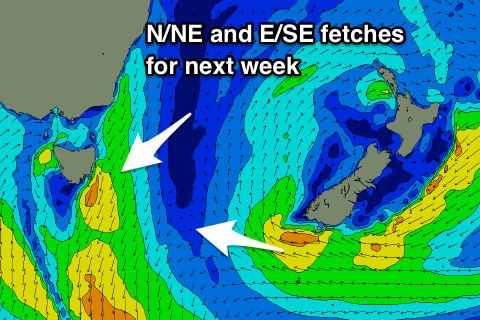
There's also likely to be a new E/SE swell in the water late week from an E/SE fetch wrapping under New Zealand as pictured.
A shallow W tending S'ly change is due to push through Wednesday and with this the N/NE windswell is expected to ease back from 2-3ft with a possible follow up S'ly swell later week as a broad Tasman Low looks to form.
More on this Monday. Have a great weekend!

