Fun surf, slower into next week, potential into the end of the month
Java, Bali, Lombok, Sumbawa forecast by Craig Brokensha (issued Thursday 13th August)
Best Days: Every day over the coming period, exposed spots through the mornings from Tuesday
This week and next week (Aug 14 - 21)
Great waves the last few days with a strong S/SW groundswell pulse, easing back into today, but hanging around 6ft on the sets across exposed breaks with a reinforcing S/SW pulse filling in this afternoon.
Into tomorrow morning, the swell should temporarily back off ahead of a late arriving S/SW groundswell to a similar 6ft on the sets across exposed breaks.
This swell will back off into Saturday from 4-6ft down further to the 4ft range Sunday morning.
Late in the day Sunday and more so Monday another similar S/SW groundswell pulse to the last few is due, with infrequent 5-6ft sets due across exposed breaks, generated by a broad but patchy polar frontal system that pushed east from Heard Island the last couple of days.
This swell will ease through Monday afternoon and further back through Tuesday and Wednesday.
 Moderate to fresh E/SE trades will continue over the weekend and next week, becoming stronger at times from Friday evening through Monday morning.
For the rest of the week unfortunately there's nothing too significant due with background levels of SW-S/SW groundswell energy ebbing and pulsing between 4-5ft at exposed breaks, mainly Thursday and Friday morning.
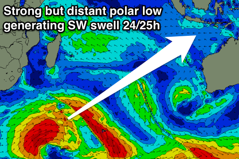
Longer term a better long-range SW groundswell is due into early the week of the 24th, but it will be extremely inconsistent, generated in our far swell window to the south-east of South Africa.
The size of this swell looks to come in around 6ft+ range, with a more consistent possibly larger swell on the cards for the following Friday/Saturday, but we'll review this next Tuesday.
16 day Bali Forecast Graph
16 day East Java Forecast Graph
16 day Sumbawa Forecast Graph


Comments
I tell ya what Craig, I can see a cyclone on the horizon for Bali - Cyclone Gary is comin' to town and gonna land right on top of Kuta. Yeeeeeeeeew. I'm looking forward to this trip almost as much as I'm looking forward to Stereos in December.
Cyclone Gary is coming to Bali via a little scenic tour of the French coastline. What are things looking like around Biarritz a week or so from now - stacked or supple???
Ha, pretty tiny next week and then some W/NW windswell for the weekend possibly to 3-4ft.
https://www.swellnet.com/reports/france/aquitaine/biarritz/forecast
Cheers Craig,
Looks like most of the action for Gaz will be on the beach instead of in the water. I do my best work above the high tide line anyway.
Those blocking highs are causing problems for the Indian Ocean.....can they just leave already!?
There's light at the end of the tunnel Mick!
Some promising activity in the Indian Ocean into the end of the month, generating swells for the start of September.