Not many clean days to chose from but there are a couple..
Primary tabs
/reports/forecaster-notes/western-australia/2019/10/28/the-onshores-return
Craig
Monday, 28 October 2019
/reports/forecaster-notes/western-australia/2019/10/25/large-long-period-swell-inbound-the-weekend
thermalben
Friday, 25 October 2019
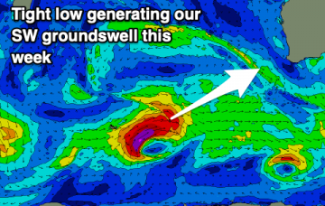
The leading edge of an incredible long period swell is due to reach the WA coast early Saturday morning. More in the Forecaster Notes.
/reports/forecaster-notes/western-australia/2019/10/23/solid-solid-solid-pockets-great-conditions
thermalben
Wednesday, 23 October 2019
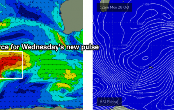
More large swells on the way, bigger than the last one! More in the Forecaster Notes.
/reports/forecaster-notes/western-australia/2019/10/21/lots-large-days-ahead
thermalben
Monday, 21 October 2019
So, we’re just playing the waiting game at the moment. More in the Forecaster Notes.
/reports/forecaster-notes/western-australia/2019/10/18/next-week-shaping-very-nicely-all-coasts
thermalben
Friday, 18 October 2019
We’re looking at freshening easterly winds on Saturday, as a trough deepens along the coast, so conditions will be clean across all regions. More in the Forecaster Notes.
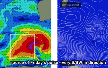
/reports/forecaster-notes/western-australia/2019/10/16/complex-period-ahead-some-good-options-across
thermalben
Wednesday, 16 October 2019
Our large S/SW tending S’ly swell is still on target for Friday. And next week looks unreal. More in the Forecaster Notes.

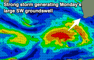
/reports/forecaster-notes/western-australia/2019/10/14/large-swells-the-charts-very-south-in
thermalben
Monday, 14 October 2019
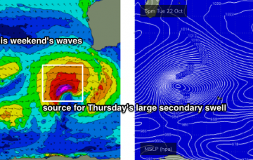
A broad, rapidly intensifying low pressure system well south of the state on Tuesday and Wednesday will occur right on the eastern periphery of our swell window, which is a shame as it’s looking to be quite a significant swell generating system - aimed nicely towards South Oz and Victoria. More in the Forecaster Notes.
/reports/forecaster-notes/western-australia/2019/10/11/good-swells-inbound-though-youll-have-work-the
Craig
Friday, 11 October 2019
Generally favourable winds for protected locations with a couple of good swells inbound.
/reports/forecaster-notes/western-australia/2019/10/09/good-swells-though-winds-are-issue
Craig
Wednesday, 9 October 2019
Plenty of fun surf on the way though winds will create a few issues and mostly favour protected spots.

/reports/forecaster-notes/western-australia/2019/10/07/fun-waves-tomorrow-tricky-thereafter-larger
Craig
Monday, 7 October 2019
Lots of swell on the cards though this week is a little hit and miss.
