Large, easing surf with slowly improving winds
Western Australia Surf Forecast by Craig Brokensha (issued Wednesday 7th August)
Best Days: Perth and Mandurah tomorrow morning, protected spots in the South West, Friday morning, Saturday in the South West, Monday selected locations
Recap
Early clean conditions across all locations yesterday but shifting and developing onshore winds kicked in quickly across the South West, a little delayed to the north. Today the South West is a mess with strong onshore winds, cleaner but a little lumpy with variable winds to the north.
A large new SW groundswell is expected to build through the day but with onshore winds across all locations.
Today’s Forecaster Notes are brought to you by Rip Curl
This week and weekend (Aug 8 - 11)
This afternoon's increase in SW groundswell should see the South West building to 10ft+ on the sets by dark today, 3ft in Mandurah and 2-3ft in Perth, with the peak being a little drawn out and similar sized surf due into tomorrow morning before easing through the day.
Conditions will remain average across the South West with a fresh SW breeze, tending S/SE later in the day, so try protected locations. Perth and Mandurah will be much better with morning E-E/NE offshore winds ahead of sea breezes.
The easing trend will be slowed into Friday as a strengthening front south-west of us today produces a moderate sized reinforcing SW swell for tomorrow afternoon and evening.
This will soften the drop in size, with Margs still expected to see 6ft sets, if not for the odd bigger sneaky one Friday morning, 2-3ft in Mandurah and 2ft+ in Perth. Winds will improve across the South West and tend more S/SE-SE, opening up a few more options, with E/NE offshores further north. Sea breezes will develop into the afternoon.
Saturday is the cleanest day in the South West with a moderate to fresh and easing E/NE breeze along with easing 4-5ft sets, 2ft max in Mandurah and 1-1.5ft Perth.
 Sunday is still looking average with the swell easing further along with fresh E/NE tending NE winds. Try swell magnets in the South West.
Later Sunday but more so Monday a new W/SW groundswell is due across the state, superseded by a larger prolonged swell into the middle of the week.
Monday's swell will be generated by an unfavourably aligned but strong mid-latitude trough/low that's formed south-east of Madagascar. An off axis fetch of S/SW gales will be generated through our western swell window, limiting the swell potential.
We should see Margs increase to 5-6ft or so, Mandurah and Perth 2ft+ and winds look to hold out of the NE as the remnants of the storm moves in slowly early next week, shifting onshore Tuesday.
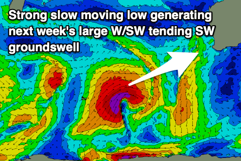
Of greater importance is the stronger and slower moving low that's forecast to develop on the tail of the trough/low, with a fetch of distant and tight severe-gale to storm-force W/SW winds broadening and remaining at severe-gale strength while moving closer towards us over the weekend, dipping slowly south-east through Sunday.
This will produce a prolonged long-period W/SW tending SW groundswell event which is due to build Tuesday and peak through Wednesday/Thursday.
At this stage we're looking at surf to 10ft to possibly 12ft in the South West, 3-4ft in Mandurah and 3ft in Perth on the sets but with onshore winds. We may see a secondary strong fetch of gales projecting up and into us on Wednesday, bringing an additional increase in local swell, but more on this Friday.

