Large swell inbound, though onshore across the South West
Western Australia Surf Forecast by Craig Brokensha (issued Monday 5th August)
Best Days: Early all spots tomorrow, Wednesday and Thursday mornings Perth and Mandurah (protected spots in the South West), Friday, South West Saturday
Recap
A drop in swell and with onshore winds across the South West Saturday, cleaner but small to tiny to the north early in the day. Come Sunday a large new W/SW groundswell came in as expected but conditions were poor with onshore winds across all locations.
Today the swell has eased back with a morning onshore wind in the South West which has since gone more variable offshore as a trough moved in from the south-west, creating cleaner conditions, onshore in Mandurah and more variable and cleaner in Perth with heavy downpours and storms.
Today’s Forecaster Notes are brought to you by Rip Curl
This week and weekend (Aug 6 - 11)
A new pulse of SW groundswell is expected tomorrow, stopping the easing trend from today and keeping the South West mostly around 4-5ft, with 2ft sets in Mandurah and 1-2ft in Perth. Winds will vary as a surface trough drifts northward during the day with early fresh SE breezes in the South West due to swing more S/SE and then S/SW-SW into the afternoon.
Perth and Mandurah will see straighter E'ly winds early before shifting more to the south and then onshore.
 Our new and larger SW groundswell for Wednesday and Thursday is still on track, generated by a slow moving frontal progression through the southern Indian Ocean over weekend and the coming days.
Varying fetches of W/SW gales have been generated through our swell window, with the storm weakening slowly while projecting closer to us this evening and tomorrow, clipping the state into the evening.
Two seperate pulses of large SW groundswell are due, the first and most consistent through Wednesday ahead of the secondary less consistent pulse Thursday morning.
We should see the South West building to 10ft+ later in the day Wednesday, easing from a similar size Thursday morning with 3ft sets in Mandurah and 2-3ft waves around Perth.
Winds still aren't looking too flash for Margs with a fresh S/SW'ly on Wednesday, lingering into Thursday. Perth and Mandurah should see morning S/SE-SE breezes, S/SW into the afternoon Wednesday and then light E Thursday morning ahead of sea breezes.
 Friday is still the day to surf the South West as winds go straight offshore out of the E, variable into the afternoon from the SE with easing sets from the 6ft range, if not for the odd bigger one. Perth and Mandurah will be smaller and easing from 2ft or so on the sets.
The surf will bottom out through the weekend with the South West being the pick under fresh E/NE-NE winds, poor Sunday with a strong N'ly tending NW breeze.
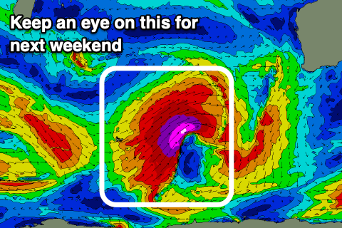
This will be associated with a deep trough moving in from the west and behind it, a significant storm that's forecast to produce a fetch of drawn out severe-gale to storm-force W/SW winds in our western swell window, slipping slowly more into our south-western swell window through the weekend.
We're currently looking at the development of an XXL groundswell event for early next week, but unfortunately with onshore winds across the South West as the remnants of the storm clips the state. It looks cleaner to the north, but we'll have a closer look at this on Wednesday.

