Large workable weekend, large swells next week
Western Australia Surf Forecast by Craig Brokensha (issued Friday 16th August)
Best Days: Protected spots tomorrow, Sunday morning, Monday through Wednesday selected spots
Recap
Fun waves across all regions yesterday morning with clean 2-3ft surf around Perth and Mandurah, back to 6ft+ in the South West with a SE breeze.
This morning all locations are poor with strengthening onshore winds out of the north-western quadrant and a mix of swells.
Today’s Forecaster Notes are brought to you by Rip Curl
This week and weekend (Aug 17 – 23)
A vigorous mid-latitude front is currently pushing into us and this will bring an increase in windswell later today and more so tomorrow, mixed in with a new large W/SW groundswell from the earlier stages of the front this week.
There's been no change to the expected size with Margs due to see 10ft+ waves, 4ft in Mandurah and 3-4ft in Perth but with strong and easing S/SW winds in the South West. Try protected spots for a wave. Perth and Mandurah should see more favourable S/SE breezes through the morning.
The swell will ease into Sunday, but our large and long-period S/SW groundswell for the South West into the afternoon is still on track.
This is being generated by a great gale to severe-gale SW fetch around a polar that's currently south-southwest of the state. The low is a touch weaker than forecast on Wednesday but we're still expected to see sets holding 10ft across the South West into Sunday afternoon, 3ft in Mandurah and 2-3ft across Perth.
Winds will also improve, great and E-E/NE across Perth and Mandurah ahead of weak sea breezes and light S/SE tending variable E ahead of sea breezes.
Monday morning will be good early with light E/NE-NE winds and the easing S/SW groundswell down from 6-8ft across the South West, 2ft+ in Mandurah and 2ft Perth. The afternoon will become wind affected as winds shift a little more N'ly.
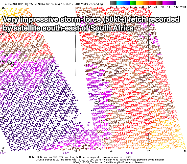
Our large and long-period W/SW groundswells for later Tuesday and Wednesday are still on track, with an initial tight low forming south-east of South Africa, producing a fetch of severe-gale W/SW winds in our far swell window.
This will produce an inconsistent but good building W/SW groundswell for Tuesday, building to 6-8ft later in the day in the South West, 2ft+ Mandurah and 2ft Perth along with favourable E/NE tending NE winds.
Our larger and more powerful and consistent swell for Wednesday is being generated by a stronger and broadening low moving in on the back of the active sea state generated by the first, with a fetch of storm-force W/SW winds being projected towards us (already picked up by satellite). We'll see the fetch backing off to severe-gale this evening, breaking down tomorrow as a burst of pre-frontal severe-gale W/NW winds fire up.
 All this activity will generate Wednesday's swell, with it due to arrive early in the morning and building to a peak into the afternoon, reaching 12ft+ across the South West magnets, 3-4ft in Mandurah and 3ft in Perth. Winds aren't great but will favour some locations with a fresh NE tending N/NE breeze. Thursday will then become poor as the swell slowly eases under a strong N/NE tending NW breeze.
The easing trend will be slowed owing to a trailing fetch of gale to severe-gale W/SW winds being aimed towards us Sunday and Monday but with those poor winds.
An overnight change may leave lingering onshore SW winds into Friday but we'll have to review this on Monday.
Longer term there's a good large long-period SW groundswell for early the following week with lighter winds, but more on this Monday. Have a great weekend!

