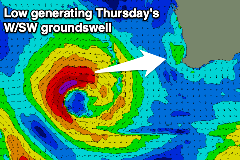
Not the best winds with large swells inbound
Western Australia Surf Forecast by Craig Brokensha (issued Friday 2nd August)
Best Days: Mandurah and Perth early tomorrow, possibly Perth and Mandurah Sunday morning, all locations through the morning Monday, Wednesday morning, Friday morning
Recap
Pumping surf across all locations yesterday with a mix of large, new long-period W/SW groundswells coming in at a clean 10ft+ in the South West, 3-4ft in Mandurah and 3ft in Perth.
Today the swell is on the ease but conditions great again early, though winds will shift more N/NE through the day.
Today’s Forecaster Notes are brought to you by Rip Curl
This weekend and next week (Aug 3 – 9)
The surf will continue to ease into tomorrow and a dawn N/NW breeze will shift W'ly through the morning across the South West, creating poor conditions. It'll be cleaner further north with a NE offshore and easing sets from 2ft in Mandurah, 1-2ft in Perth.
 Our large and westerly swell for Sunday is still on track with a strong mid-latitude low currently forming to our west. A tight fetch of gale to severe-gale W/SW winds will be aimed towards us, generating a large and consistent W'ly swell peaking Sunday morning to 10ft+ in the South West, 3-4ft in Mandurah and 3ft in Perth.
Winds will unfortunately linger out of the W on Sunday across the South West, with Perth seeing variable winds and cleaner conditions, a little dicey around Mandurah but also likely variable.
Winds look to remain onshore across nearly all locations on Monday morning, but with the pressure gradient weak, we may see more variable winds developing at the coastal interface from Margaret River to Perth in the hours after dawn.
Size wise we'll be looking at easing 6ft+ surf in the South West, 2ft to maybe 3ft Mandurah and 2ft+ in Perth.
We'll likely see winds tend back to the SE-S/SE on Tuesday morning along with a background pulse of SW groundswell. The source of this will be a relatively weak polar front, likely just maintaining 4-5ft sets across the South West, 1ft to maybe 2ft in Mandurah and tiny in Perth.
A stronger and slow moving polar progression projecting from the southern Indian Ocean up towards us through early next week will generate a larger SW groundswell event for Wednesday and Thursday.
A steady increase in size is due through Wednesday to 10ft+ across the South West later in the day, 3ft in Mandurah and 2-3ft in Perth. The swell is then due to ease from a similar size Thursday, smaller into the weekend.
Conditions on Wednesday morning look OK with a morning S/SE breeze in the South West, SE further north, but a front clipping the state on Thursday unfortunately looks to bring SW tending S/SW winds. Into the end of the week and weekend as the swell eases winds will finally start to improve, best next Saturday in the South West.
Longer term we're likely to see a vigorous and high riding mid-latitude frontal progression pushing across us, bringing large onshore swells, but more on this Monday. Have a great weekend!

