We have some small E’ly swell on the way for SE Qld, and then a run of solid S'ly swell, biggest in Northern NSW. More in the Forecaster Notes.
Primary tabs
/reports/forecaster-notes/south-east-queensland-northern-new-south-wales/2020/04/08/dominant-swell
thermalben
Wednesday, 8 April 2020

/reports/forecaster-notes/south-east-queensland-northern-new-south-wales/2020/04/06/coupla-swell
thermalben
Monday, 6 April 2020
We’ve got a couple of source on the cards but nothing overly special. More in the Forecaster Notes.
/reports/forecaster-notes/south-east-queensland-northern-new-south-wales/2020/04/03/extended-run
thermalben
Friday, 3 April 2020
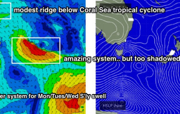
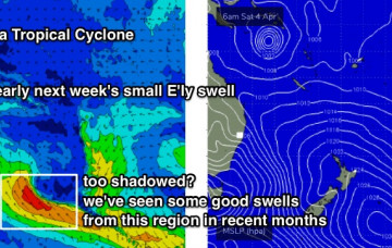
TC Harold is expected to remain behind the New Caledonian swell shadow this weekend, and upon re-entering our swell window on Monday and Tuesday, will likely move too fast to the east, which is a poor storm track for our swell prospects anyway. More in the Forecaster Notes.
/reports/forecaster-notes/south-east-queensland-northern-new-south-wales/2020/04/01/patchy-the-next
thermalben
Wednesday, 1 April 2020
Next week has plenty of swell sources on the cards, though things have changed a little since Monday’s notes were prepared. More in the Forecaster Notes.
/reports/forecaster-notes/south-east-queensland-northern-new-south-wales/2020/03/30/coupla-days-small
thermalben
Monday, 30 March 2020
Model guidance is also suggesting a tropical cyclone may form in the Coral Sea this weekend. More in the Forecaster Notes.
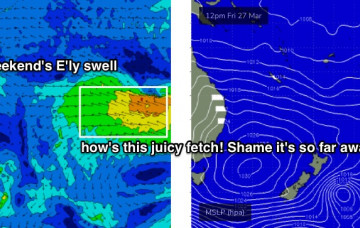
/reports/forecaster-notes/south-east-queensland-northern-new-south-wales/2020/03/27/peaky-mix-swells
thermalben
Friday, 27 March 2020
It will be worth keeping an eye on our far eastern swell window for the long term period. More in the Forecaster Notes.
/reports/forecaster-notes/south-east-queensland-northern-new-south-wales/2020/03/25/lots-autumnal
thermalben
Wednesday, 25 March 2020
There's a bevy of trade swells on tap for SE Qld, and we also have more southerly swell on the way - but mainly for Northern NSW. More in the Forecaster Notes.
/reports/forecaster-notes/south-east-queensland-northern-new-south-wales/2020/03/23/lots-south-swell
thermalben
Monday, 23 March 2020
The weekend looks a bit tricky, but there is certainly some potential for good waves as our eastern swell window lights up again. More in the Forecaster Notes.
/reports/forecaster-notes/south-east-queensland-northern-new-south-wales/2020/03/20/southerly-swells
thermalben
Friday, 20 March 2020
It’s been a great week of east swell, eh? Unfortunately, we are now well and truly on the backside of this event. But, there's plenty of south swell on the way. More in the Forecaster Notes.
/reports/forecaster-notes/south-east-queensland-northern-new-south-wales/2020/03/18/more-the-east
thermalben
Wednesday, 18 March 2020
Looks like more E’ly swell for the rest of the week. But there's a few risks in the wind department. More in the Forecaster Notes.
