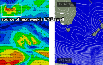
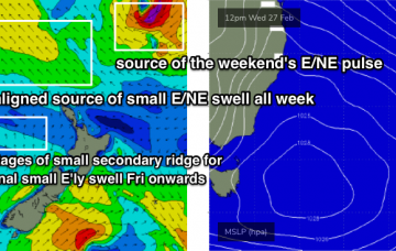
There isn’t a great deal of excitement expected for the next few days. However, a tropical system is expected to begin slowly deepening south from Tonga on Friday, and will generate a long lived E/NE swell event next week.
Primary tabs
/reports/forecaster-notes/sydney-hunter-illawarra/2019/03/13/small-beachies-dominate-few-days-next
thermalben
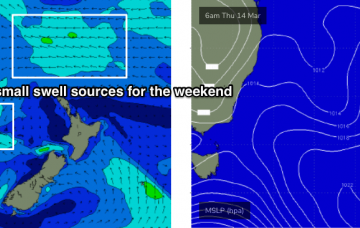
Wednesday, 13 March 2019
/reports/forecaster-notes/sydney-hunter-illawarra/2019/03/11/not-particularly-great-week-waves-ahead
thermalben
Monday, 11 March 2019
There’s a lot of interesting features on the long term charts, some of which are quite plausible, and some of which are much less certain and require a variety of circumstances to eventuate. More in the Forecaster Notes.
/reports/forecaster-notes/sydney-hunter-illawarra/2019/03/08/lots-unusual-swell-sources-ahead-good
thermalben
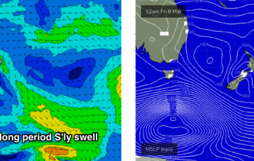
Friday, 8 March 2019
No change to the weekend outlook - it still looks pretty tricky.
/reports/forecaster-notes/sydney-hunter-illawarra/2019/03/06/interesting-south-swell-weekend
thermalben
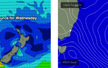
Wednesday, 6 March 2019
The weekend looks a little tricky. And, the wave models are not properly picking up any of the swells I am expecting, so this reduces confidence in the outlook.

/reports/forecaster-notes/sydney-hunter-illawarra/2019/03/04/lots-fun-swells-multiple-sources
thermalben
Monday, 4 March 2019
Despite the expected longer period E/NE groundswell from TC Pola not yet showing, I still think we’re going to see some new energy later today and into Tuesday morning. More in the Forecaster Notes.
/reports/forecaster-notes/sydney-hunter-illawarra/2019/03/01/building-swells-out-ene-biggest-early
thermalben
Friday, 1 March 2019
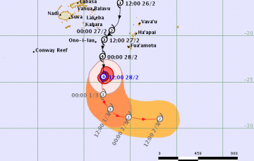
Severe Tropical Cyclone Pola - currently Category 4, south of Fiji - will curve to the south-east over the coming days.
/reports/forecaster-notes/sydney-hunter-illawarra/2019/02/27/fun-outlook-ahead-looking-best-early
thermalben
Wednesday, 27 February 2019
Tropical Cyclone Pola is currently E/SE of Fiji, and tracking southwards.

/reports/forecaster-notes/sydney-hunter-illawarra/2019/02/25/plenty-fun-waves-ahead-entire-forecast
thermalben
Monday, 25 February 2019
All swell sources will ease through Tuesday.
/reports/forecaster-notes/sydney-hunter-illawarra/2019/02/22/average-weekend-winds-though-plenty
thermalben
Friday, 22 February 2019
So, the current NE swell from TC Oma will probably be short lived.
/reports/forecaster-notes/sydney-hunter-illawarra/2019/02/20/stacks-swell-ahead-just-not-source-you
thermalben
Wednesday, 20 February 2019
Of course, TC Oma is the only weather system on the synoptics of interest to us. But, it's not the primary swell source for Southern NSW this forecast period. More in the Forecaster Notes.
