Building swells out of the E/NE, biggest early next week
Sydney, Hunter and Illawarra Surf Forecast by Ben Matson (issued Friday 1st March)
Best Days: Most days should have fun waves.
Recap: Wave heights held 2-3ft out of the east on Thursday but have eased a smidge today, more like 2ft+. Winds have been light through the mornings with afternoon sea breezes.
This weekend (March 2 - 3)
Today’s Forecaster Notes are brought to you by Rip Curl
A broad ridge through the Northern Tasman Sea will be our predominant swell source this weekend, slowly building E/NE swells across Southern NSW.
Given today’s slightly undercooked surf, I’m going to peg tomorrow morning of a similar size (2ft+), but we can still anticipate a very slow building trend throughout the day and into Sunday too.
By later Sunday afternoon we should see inconsistent 3-4ft sets at most open beaches though it’ll be rather inconsistent at times. Expect smaller surf prior to then.
There is a threat of north-easterly winds all weekend, but I don’t think there’ll be too much strength in it and we should - as a minimum - have reasonable periods of lighter, possibly variable conditions. But, it’s unlikely to be perfectly clean.
The models also have a tiny long period S’ly swell in the water on Sunday but I am doubtful that we’ll see much size from it, as it was generated in a very rare, flukey part of our swell window. Keep an eye out at south swell magnets though. Perhaps a few stray 2ft+ sets if we’re super lucky.
Next week (Mar 4 onwards)
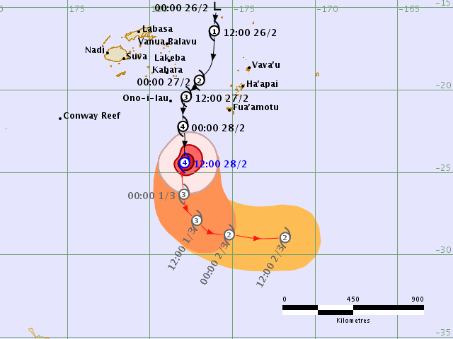
Severe Tropical Cyclone Pola - currently Category 4, south of Fiji - will curve to the south-east and then east over the coming days, into the South Pacific behind the swell shadow of New Zealand.

Although it’s a small system with a narrow core of the strongest winds, it is however interacting with a broad ridge to the south within our swell window and this will become a decent source of stronger E/NE swell early next week.
Wave heights are expected to build steadily through Monday, reaching a peak in size late in the day or early Tuesday and then slowly easing. The cyclone swell will be a short lived event in the middle of a broad, more sustained pattern of sideband E/NE swell from the ridge. So, background swell should manage 3-4ft for most of this period though we’ll see a kick in size at the height of the swell that could push another foot above this (occasional 4-5ft+ sets, either late Monday or early Tuesday).
Local winds look to be an issue, but there is some promise for periods of workable conditions.
A high in the eastern Tasman Sea will maintain N’ly breezes across the region, and they’ll freshen throughout this period as a shallow trough moves up from the Far South Coast. The trough may even deliver periods of light winds, and possibly a brief S’ly change to some regions - though the latter won’t be very strong nor last very long.
At this stage early Tuesday looks like it’ll have the most potential at seeing this southerly incursion. Locations south from Wollongong have a greater chance at more extended periods of light variable winds too. Locations further north from Sydney (i.e. Hunter) have a reduced chance of seeing the more favourable conditions.
The associated N’ly flow off the coast will also generate some local windswell though it won’t be the dominant swell source by any stretch.
Long term has a more vigorous S’ly change overnight Wednesday though with only a brief flush of associated southerly swell. Small trade swells are expected to continue into the long term, and a strong front and low is expected to cross the Tasmanian divide later in the week, leading to a more significant southerly swell over the weekend or early in the following week.
More on this on Monday. Have a great weekend!


Comments
Up now. Apologies for the delay. Been a looooong day (sans surf, too), with many more to come (I'm at the Noosa Festival of Surfing).
Not a bad looking system.

Hey Ben is that cyclone swell looking like being in the water tomorrow morning or later in the day? Our forecast (this site) has it 1m at 6am and 1.7 at lunch.
No way of knowing. Without any buoys in the middle of the Tasman Sea to verify the forecast, we can only go on model guidance.
Thanks a lot mate keep up the good work
stupid wind
One small issue with this warm water is the sea lice. Cannot stop itching and they're getting in everywhere. Wouldn't change it though, it's been amazing in.
there was a few 4ft sets rolling in around lunch but they were in the minority. fun though.
Hey Ben, how's the wind looking for Wednesday morning (tomorrow) in Sydney (nth beaches)?