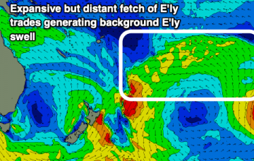
There’s a lot to digest this week. Let’s look at SE Qld first, as it’s relatively straightforward. More in the Forecaster Notes.
Primary tabs
/reports/forecaster-notes/south-east-queensland-northern-new-south-wales/2019/05/20/small-surf-se-qld
thermalben
Monday, 20 May 2019

/reports/forecaster-notes/south-east-queensland-northern-new-south-wales/2019/05/17/similar-swells
thermalben
Friday, 17 May 2019
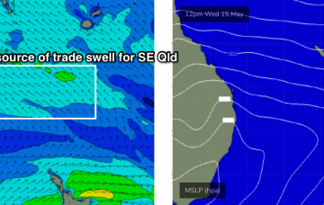
It’s almost a case of rinse and repeat for the short term forecast. More in the Forecaster Notes.

/reports/forecaster-notes/south-east-queensland-northern-new-south-wales/2019/05/15/generally-more
thermalben
Wednesday, 15 May 2019
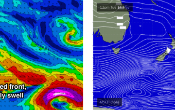
It’s looking like we’ll see very similar conditions throughout SE Qld and Far Northern NSW for the next few days. More in the Forecaster Notes.
/reports/forecaster-notes/south-east-queensland-northern-new-south-wales/2019/05/13/fun-small-mix-sly
thermalben
Monday, 13 May 2019
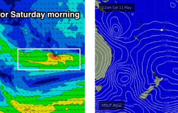
Although our current S’ly swell will ease back through Tuesday, we’ve got got a series of small long range S’ly swells expected for the next five days.
/reports/forecaster-notes/south-east-queensland-northern-new-south-wales/2019/05/10/dynamic-though
thermalben
Friday, 10 May 2019
Large southerly swells will start to show across the Mid North Coast later Saturday, peaking overnight across Northern NSW and then easing rapidly throughout Sunday. More in the Forecaster Notes.

/reports/forecaster-notes/south-east-queensland-northern-new-south-wales/2019/05/08/large-number
thermalben
Wednesday, 8 May 2019
OK, there’s a lot to unpack for the weekend. More in the Forecaster Notes.
/reports/forecaster-notes/south-east-queensland-northern-new-south-wales/2019/05/06/dynamic-series
thermalben
Monday, 6 May 2019
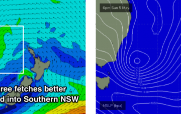
The Tasman Low responsible for our current south swell is a fascinating system. More in the Forecaster Notes.
/reports/forecaster-notes/south-east-queensland-northern-new-south-wales/2019/05/03/peaky-beachies
thermalben
Friday, 3 May 2019
The main feature for the weekend is a gusty S’ly change pushing up the coast. It’ll reach the Mid North Coast later Saturday and then extend across remaining coasts overnight, resulting in gusty S/SW winds on Sunday. More in the Forecaster Notes.
/reports/forecaster-notes/south-east-queensland-northern-new-south-wales/2019/05/01/plenty-swell
thermalben
Wednesday, 1 May 2019
We’re locked in a somewhat stationary synoptic pattern at the moment, thanks to a slow moving high pressure system setting up camp in the eastern Tasman Sea.
/reports/forecaster-notes/south-east-queensland-northern-new-south-wales/2019/04/29/easing-sly-swell
Craig
Monday, 29 April 2019
Not the most ideal winds over the coming period until the weekend. Easing levels of S'ly swell tomorrow ahead of a mix of building E'ly trade-swells.