New swell for the weekend but onshore as it peaks, better next week
Western Australian forecast by Craig Brokensha (issued Friday February 28th)
Best Days: Tomorrow morning in the South West, Sunday morning in the South West, Wednesday
Features of the Forecast (tl;dr)
- Moderate + sized SW swell for tomorrow PM (smaller in the AM)
- E/SE-E winds tomorrow AM ahead of strong sea breezes, S/SE to the north in the AM
- Easing swell Sun with SE winds in the South West through the AM, E/SE to the north
- Increasing W/SW-SW tending stronger W/NW winds Mon with small to tiny surf
- Mod-large, mid-period W/SW swell building slowly Tue, peaking Wed
- Strong S-S/SE winds Tue, strong E/SE tending SE Wed
Recap
Wednesday’s swell eased back into yesterday but we saw fun waves across all coasts though a little wind affected in spots thanks to the extra bit of south in the wind.
Today’s pulse of new mid-period SW swell has come in a little bigger than expected with surf to 6ft in the South West, 2ft Mandurah and Perth under improving winds. Conditions got better through the morning but are now deteriorating again.
This weekend and next week (Feb 29 - Mar 7)
We’ve got one more pulse of swell due out of the current progression of frontal systems south-west of the state.
The frontal progression linked to this formed a little later than expected but wind speeds were a little stronger than the source of today’s swell.
What this should result in is a moderate + sized pulse of slightly stronger SW swell tomorrow afternoon, with the morning falling slightly between pulses.
The South West should build to 6ft+ with a light E-E/SE offshore across the South West and S/SE winds to the north, giving into sea breezes as the swell fills in.
Sunday should be doable but the swell will be easing from 3-5ft in the South West with small to tiny waves to the north under a SE breeze (E/SE to the north).

Monday will be a lay day with the swell fading away and an approaching frontal progression will bring increasing SW tending W-W/NW winds. Perth and Mandurah are likely to see early variable winds but with no size.
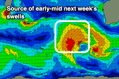
Now, this frontal progression should generate a moderate to large sized increase in mid-period W/SW swell thanks to a broad, slow moving fetch of strong W/SW-SW winds projecting up and into us through the weekend.
An initial increase in weak, mid period W/SW swell is due Tuesday but Wednesday should reveal all the size with 6-8ft sets due in the South West, 2ft to occasionally 3ft in Mandurah and 2ft+ across Perth.
Conditions look good as well with a trough bringing unfavourable, strong S-S/SE winds Tuesday, quickly swinging E/SE Wednesday but with strength.
Winds will deteriorate later week as the swell eases, while longer term we may see a new swell for next weekend. The models diverge on this outcome a little so check back here on Monday. Have a great weekend!


Comments
Chinese surf team is on its way to surf MB on Big Wednesday