Poor tomorrow, better Friday
Western Australian forecast by Craig Brokensha (issued Wednesday February 26th)
Best Days: South West and Mandurah Friday morning, the South West Sunday morning, Wednesday morning
Features of the Forecast (tl;dr)
- Easing swell tomorrow with S-S/SE winds, tending stronger S/SW through the day
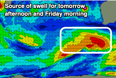
- Moderate sized, mid-period SW swell for later tomorrow and Fri AM, easing
- Light to moderate E/SE-SE winds Fri AM ahead of sea breezes
- Moderate sized SW groundswell building Sat, peaking in the PM
- Fresh S/SE tending strong S/SW winds Sat
- Rapidly easing swell Sun with moderate E/SE-SE winds ahead of strong sea breezes
- Moderate + sized mid-period SW swell filling in Tue with strong S/SE winds, easing Wed under strong E/SE tending SE winds
Recap
Yesterday wasn’t great with a slowly building, long-range W/SW groundswell with fresh onshore winds in the South West, cleaner to the north but small to tiny.
Today we’ve got much better conditions and surf still to 6ft in the South West thanks to a reinforcing SW swell with slow 1-2ft sets across Perth and Mandurah.

Great surf this morning in the South West
This week and weekend (Feb 27 - Mar 2)
Tomorrow looks like a lay day as the current swell continues to ease along with unfavourable S-S/SE winds, strengthening from the S/SW through the day thanks to a trough clipping us.
Friday looks much cleaner thanks to an E/SE-SE offshore and swell wise, a new mid-period swell that’s due later tomorrow, should offer fun sized sets across the South West.

It’s being generated by a fetch of strong to near-gale-force W/NW winds currently passing south-west of us, though it won’t be to the size of today’s swell.
Surf to 4-5ft+ is due in the South West, 1-2ft Mandurah and tiny across Perth before easing through the day.
We then look at our stronger pulse of SW groundswell for Saturday, generated by a late forming but slightly stronger low firing up directly south-west of us on Friday.
A fetch of fast moving, W’ly gales should produce a short-lived spike of SW groundswell to 6ft in the South West through the afternoon, 2ft Mandurah and 1-2ft Perth later.

This swell is due to ease quickly into Sunday and local winds aren’t ideal at all, moderate to fresh S/SE Saturday morning ahead of the swell, with strong S/SW sea breezes as it peaks, better Sunday and E/SE-SE during the morning as the swell fades.
Into early next week, a broad but not overly strong frontal progression projecting up towards us on the weekend should generate a moderate + sized mix of swells for Tuesday/Wednesday. The size doesn’t look to be anything overly significant at this stage with strong S/SE winds as it peaks Tuesday, cleaner Wednesday but windy under strong E/SE offshores as it eases.

