Trickier period but with windows of fun surf

Western Australian forecast by Craig Brokensha (issued Friday February 21st)
Best Days: Protected spots tomorrow, Sunday morning, Wednesday morning, Thursday morning in the South West, Friday morning
Features of the Forecast (tl;dr)
- Moderate + sized, mid-period S/SW swell building tomorrow, peaking into the PM, easing Sun while tending more S
- Gusty S/SE winds tomorrow, strengthening from the S into the PM (SE tending S/SW winds in metro locations)
- Mod-fresh E winds Sun ahead of sea breezes
- Fading surf Mon with S/SE-SE tending SW winds
- Moderate + sized, inconsistent W/SW groundswell building Tue, peaking later, easing Wed, mixed in with mid-period SW swell
- W/SW winds Tue, freshening (variable to the north early)
- SE tending S/SW winds Wed
- Moderate + sized mid-period SW swell Fri with E/SE tending S/SW winds
Recap
A slow moving trough started moving in through yesterday with most spots seeing onshore winds and tiny waves across the metro locations. The South West saw varying conditions with onshore winds on the northern half of the cape, cleaner from Margaret River south along with some small 3ft runners in the morning.
Today all locations are onshore and average with a small lift in swell across the South West and Mandurah.
This week and weekend (Feb 22 - 28)
Today’s increasing onshore winds are linked to a strengthening low to our south and unfortunately after being upgraded on Wednesday, the low has been slightly downgraded in subsequent updates, with fetches hardly reaching gale-force at its core.
This looks to result in less size and period, which will in turn lead to less size getting into more protected spots which will be clean out of the predominant S’ly winds.

Strong, slow moving S/SW winds now only look to produce a moderate + sized pulse of mid-period S/SW swell tomorrow, peaking into the afternoon across all locations (later Perth and Mandurah).
The South West should build to 6ft+ tomorrow with 2ft+ waves in Mandurah, 2ft across Perth later but with unfavourable, gusty S/SE winds in the South West, more SE to the north for a period during the morning ahead of S’ly winds into the afternoon (S/SW to the north).
Sunday still looks clean with a moderate to fresh, E/SE offshore wind but easing S’ly swell from 4-5ft on the South West south magnets, 2ft Mandurah and 1-2ft Perth.
Monday will be smaller again with S/SE-SE tending SW winds as another trough moves in from the west.
Winds look to linger out of the W/SW on Tuesday across the South West (more variable to the north) along with a new, inconsistent W/SW groundswell on the build.
As touched on in Wednesday’s notes, a strong low forming south-east of South Africa has generated a tight fetch of gale to severe-gale W/SW winds but is now weakening on approach towards the Heard Island region.
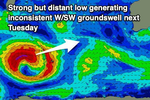
An inconsistent, moderate + sized W/SW groundswell should build to 6ft+ in the South West through the afternoon, 2ft Mandurah and 1-2ft Perth but with sea breezes.
The swell should ease Wednesday as winds swing more SE, mixed in with some closer-range mid-period energy generated by a weak frontal system firing up south-west of us over the weekend.
Easing surf from the 6ft range is due in the South West, 2ft Mandurah and 1-2ft Perth.
A stronger, trailing frontal system looks to produce a better pulse of mid-period SW swell for Friday, though only likely to 4-6ft in the South West. Conditions look good under offshore winds though.
Longer term, there’s the chance for a stronger low firing up south-west of us late week, producing a larger groundswell for the weekend. The models diverge a little regarding this though, so check back Monday. Have a great weekend!