Indonesia/Maldives forecast Apr 8

Indian Ocean Basin analysis by Craig Brokensha (issued Tuesday 8th April)
This week through next (Apr 9 - 18)
The weekend offered fun waves with the arrival of a new S/SW swell, easing into yesterday morning ahead of an acute and funky S’ly swell across the region this morning.
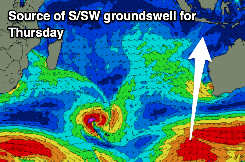
This swell is due to ease through tomorrow, while an inconsistent S/SW groundswell should be seen into Thursday, generated by a poorly aligned but strong polar frontal progression that formed south-southwest of Western Australia. This swell actually performed well across Western Australia yesterday and should provide a fun increase in size but will be inconsistent.
Expect easing surf into Friday ahead of our new, inconsistent pulses of building SW groundswell into later Saturday but more so Sunday/Monday.
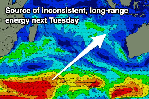
It’s a tricky episode of swell, with the long-period energy shown through Saturday generated by a strong but very distant low that formed south-west of South Africa last week. This will be extremely inconsistent and unlikely to offer any major size though try late in the day for the energy.
We’ve then got two separate pulses of better swell due into Sunday/Monday and then Tuesday, with a secondary strong low firing up to the south of South Africa yesterday, generating a great fetch of gale to severe-gale W’ly winds.
The storm has since weakened and fast tracked east, producing a much weaker fetch of elongated, strong to sub-gale-force W/SW winds extending from the Heard Island region towards Western Australia.
What we can expect is an inconsistent SW groundswell from the earlier but distant stages of the low, arriving later Monday but into Tuesday morning next week, with more consistent mid-period SW swell arriving ahead of this through Sunday/Monday.

Overall the swell pulses look more in the 6ft to at times 8ft range from Sunday afternoon through Tuesday morning.
We should also see the E/SE-SE trades kick in this week (variable offshore in the morning) before easing Sunday and swinging back to the west for next week. This will be as a tropical depression possibly interacts with our local winds but we’ll confirm this Thursday.
Longer term westerly winds look to persist with smaller levels of swell as the Indian Ocean goes a little quiet. More on this Thursday.
In the Mentawais weak S/SE-SE trades have developed but these will ease back from tomorrow but more so Thursday and remain variable into Friday. NW winds look to develop back through the weekend, easing into next week.
----------------------------------------------
Maldives:
A small pulse of mid-period S/SE swell was seen over the weekend, with it easing into yesterday.
Our next pulse of SE energy should be seen building through tomorrow, peaking Thursday/Friday morning and then easing into the afternoon and the weekend, with nothing to really follow it up.
This will be a less consistent, distant pulse generated by a heat trough sitting west of Western Australia late last week and over the weekend.
Looking to the south, the first good pulse of S/SW groundswell is due later Thursday and Friday across the southern atolls, generated by the strong distant low that formed south-west of South Africa.
It looks moderate in size, likely holding Saturday ahead of our slightly stronger S/SW groundswell into Sunday, produced by the secondary low firing up south-east of South Africa.
Local winds have freshened from the W/SW-SW today and will persist over the coming days, possibly strong at times, easing slowly on the weekend and tending more W/NW into next week.
Eastern Indonesia:
Small-moderate sized mid-period S’ly swell this morning to 3-5ft across exposed breaks, easing.
Small-moderate sized S’ly groundswell for later Wednesday but more so Thursday to 4-5ft across exposed breaks, easing slowly Friday.
Long-range, very inconsistent SW groundswell building Saturday afternoon, reaching 4-5ft+ late across exposed breaks.
More consistent SW swell building through Sunday, reaching 6ft to possibly 8ft through the day, holding Monday morning, easing ahead of a stronger but less consistent groundswell Tuesday morning to 6ft to occasionally 8ft, easing Wednesday.
Moderate E/SE-SE trades this week (variable offshore each morning). Winds easing Sunday and swinging back to the west for next week
Uluwatu 16-day Forecast Graph/WAMs
Western Indonesia/Mentawais/South Sumatra:
Small-moderate sized, mid-period S/SE swell for Tuesday to 3-5ft, easing Wednesday.
Small-moderate sized mid-period SW swell for later week.
Long-range, very inconsistent SW groundswell building Saturday afternoon, reaching 4-6ft late across exposed breaks.
Mod-large, inconsistent SW swell building Sunday, reaching 6ft+ into the afternoon, easing slowly Monday from a similar size.
Strong, less consistent long-period SW groundswell for later Monday but more so Tuesday morning to 6ft to possibly 8ft, easing.
Weak S/SE-SE winds today and tomorrow, tending variable Thursday and remaining variable Friday. NW winds developing through the weekend, easing into next week.
Mentawai 16-day Forecast Graph/WAMs
Maldives:
Inconsistent SE trade-swell building slowly tomorrow, peaking Thursday/Friday to 4ft across exposed breaks, easing into the weekend and next week.
Moderate + sized, inconsistent S/SW groundswell building later Friday, peaking Saturday to 4-5ft across the southern atolls (smaller Male).
Slightly better S/SW groundswell Sunday to 4-6ft across the southern atolls, easing slowly next week.
Fresh W/SW-SW winds today and through the rest of the week (possibly strong at times), easing slowly on the weekend and tending more W/NW into next week.
Comments
Latest notes are live.
Thanks Craig..
It’s tiny
Today's S'ly swell was a flukey one and only going to impact some spots, more to the west, the better. Anywhere east of a line drawn north from the WA coastline and much much smaller if anything.
Cheers Craig, heading over next week for some east coast action, looks like a good 4 days at least .
When will these tropical lows just go away every week nearly they
pop up and ruin everything. Should be constant trades by now