Upgrade in the weekend's swell but with tricky winds
Western Australian forecast by Craig Brokensha (issued Wednesday February 19th)
Best Days: Protected spots Saturday, Sunday morning in the South West, possibly Tuesday morning and Wednesday morning
Features of the Forecast (tl;dr)
- Pre-dawn variable winds tomorrow, freshening from the W around dawn
- Small to moderate sized SW swell building tomorrow, easing Fri
- Fresh to strong SW winds Fri, lighter to the north
- Mod-large mid-period S/SW swell filling in Sat (peaking PM to the north) with fresh to strong S/SE winds, easing a touch through the day
- Rapidly easing S'ly swell Sun with E/SE offshores ahead of sea breezes
- Smaller Mon with early S/SE tending W/SW winds
- Moderate + sized W/SW groundswell building Tue, peaking later, easing Wed
- Variable offshore winds Tue AM ahead of sea breezes
- S/SE-SE tending S/SW winds Wed
Recap
Monday’s good kick in groundswell held well into yesterday morning with 6ft surf in the South West, 2ft Mandurah and 1-2ft Perth.
Today the swell has really backed off with 3-4ft leftovers down in the South West, tiny across metro locations.
This week and next week (Feb 20 - 28)
Tomorrow is dicey wind wise as a trough moves across us with early variable winds due to freshen out of the west. This now looks to be right on dawn across the South West and a little more delayed to the north, but swell wise we’re only expected to see a small lift in mid-period energy.
Not worth worrying about.

Come Friday, lingering fresh to strong SW winds in the South West (lighter to the north) will continue to create average conditions, associated with a strengthening low south of us.
This low is due to project a fetch of strong to gale-force S/SW winds through our southern swell window Friday, with an upgrade in the expected size due across southern regions owing to its slow moving nature.
The South West should build to 6-8ft across exposed breaks through the day Saturday with Mandurah building to 2ft+ into the afternoon with 1-2ft sets in Perth but with fresh to strong S/SE winds, easing a little through the day.
Sunday will see great E/SE offshore winds across all locations but with a rapidly easing S’ly swell from 3-5ft in the South West, 1-2ft Mandurah and 1-1.5ft Perth.

Moving into next week and the swell will continue to bottom out Monday as a trough brings S/SE tending W/SW-SW winds, possibly easing into Tuesday as a new, long-range W/SW groundswell fills in.
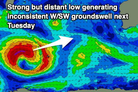
The source will be a strong but short-lived low forming south-east of South Africa tomorrow, projecting a fetch of gale to severe-gale W/SW winds through our western swell window.
The low will weaken when crossing a line running north of Heard Island, with a moderate + sized W/SW groundswell due to build Tuesday, peaking into the afternoon to 6ft+ in the South West, 2ft Mandurah and 1-2ft Perth.
If we’re lucky we’ll see variable tending offshore winds on Tuesday morning, more reliable SE Wednesday morning. Longer term the outlook is slower but check back here Friday for any changes.

