Trickier period, best now and over the coming days

Western Australian forecast by Craig Brokensha (issued Monday February 17th)
Best Days: Today, tomorrow morning in the South West and Mandurah, Wednesday and Thursday mornings in the South West for the keen
Features of the Forecast (tl;dr)
- Easing W/SW groundswell tomorrow with strong but easing E/SE winds ahead of S/SE sea breezes to the south, with late arriving sea breezes to the north
- Smaller Wed with strong but easing E/SE winds ahead of relatively weak sea breezes
- Small mid-period SW swell for Thu with increasing W/SW winds to the north, light E to the south for a period during the morning
- Strong S/SW winds Fri
- Moderate sized S'ly swell Sat with strong S/SE-SE winds
- Fading swell Sun with E winds ahead of sea breezes
Recap
The South West offered fun waves on the weekend with clean conditions and surf in the 4ft range Saturday, clean again yesterday but a little smaller.
This morning started slow and windy, but our new groundswell is now filling in with 6ft+ sets across the South West magnets under a strong cross-shore wind.

New swell on the build this morning
This week and weekend (Feb 18 - 23)
Today's increase in groundswell is due to peak this afternoon/evening and start easing into tomorrow, back from the 5ft range in the South West, 1-2ft Mandurah and 1-1.5ft across Perth.
Winds look great and strong but easing out of the E/SE tomorrow morning ahead of strong S/SE breezes in the South West through the afternoon and late sea breezes to the north.
Wednesday will be smaller again as strong E/SE winds persist, easing through the day ahead of relatively weak sea breezes.
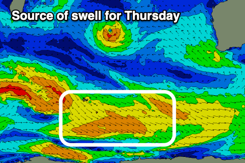
Thursday is a tricky one, with a deepening trough - come low due to bring increasing onshore winds from dawn across Perth/Mandurah while the South West might see early light E/SE winds before shifting W/SW into the afternoon and strengthening.
A new mid-period SW swell is due to be in the water on Thursday morning as well generated by relatively weak but persistent fetches of W/NW winds on the polar shelf today and tomorrow.
This will bring a fun increase to 4ft on the sets across the South West, tiny to the north. Friday looks poor with strong S/SW winds as the low moves further east.
The low itself deepening to our south on Friday will generate a fetch of strong S/SW winds late in our swell window, kicking up an acute S’ly swell for Saturday to 4-5ft across selected spots in the South West, tiny to the north.
Winds will be average for these spots in any case with a strong S/SE-SE morning breeze, cleaner Sunday but small and fading.
Longer term the outlook remains wishy washy, so make the most of today and the coming days.