Flukey period of swell and winds
Western Australian Surf Forecast by Craig Brokensha (issued Monday January 15th)
Best Days: Keen surfers tomorrow as winds improve and early Wednesday on the magnets, Friday morning in the South West
Features of the Forecast (tl;dr)
- Moderate sized, flukey S swell for tomorrow, arriving arvo to the north
- Strong SE winds, tending E/SE later in the South West tomorrow and E/SE-E to the north
- Fading swell Wed with E/NE tending NW winds
- W winds Thu
- Inconsistent SW groundswell peaking through the day Fri with S/SE tending SW winds
- Fading swell Sat with S/SE-SE tending SW winds
Recap
Clean conditions and fun surf on Saturday with a slow, building swell through the day that started in the 3-4ft range on the magnets, becoming a little stronger through the day with winds remaining favourable into the early afternoon. Perth and Mandurah were tiny to flat.
The swell eased into yesterday with a fresher offshore wind, best on the small wave breaks, tiny today.
This week and weekend (Jan 16 – 21)

With the surf bottoming out today, we've got a tricky and funky outlook for tomorrow.
A small surface low forming to our west today is now tracking east, bringing the strong S/SE winds to the South West which will swing more SE at times tomorrow morning, then more E/SE into the late afternoon/evening along with a new, acute S'ly swell.
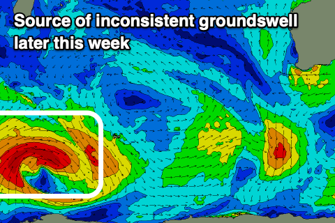
This swell is from a tricky source, with it generated by strong S/SE winds on the southern flank of a trough line running south of the low today (shown left). This should generate some radially spreading swell, and the size should be up on today but it'll be focussed into south magnets which will be cross onshore in the morning, a bit better after lunch. Sets to 4-5ft are likely on these breaks, much smaller at other spots. Perth and Mandurah might bump to 1.5ft into the afternoon so there's a chance for an arvo paddle on micro runners.
This swell will fade rapidly into Wednesday under E/NE tending NE winds, NW into the afternoon. There isn't likely to be anything left of substance for a surf in the South West.
Thursday will be a lay day, while come Friday, our inconsistent SW groundswell is due to peak, generated by a strong polar low that formed south of South Africa on the weekend. A good but tight fetch of W/SW gales were generated, with the low breaking down west of the Heard Island region.

This will result in an inconsistent but fun swell for Friday, peaking through the day to 4-5ft+ across the South West magnets, tiny to the north.
Conditions are now looking a little better than expected last Friday for this coming Friday, with W'ly breezes on Thursday due to clear to the east and a new, filling high should see winds swing back to the S/SE in the morning ahead of sea breezes.
S/SE-SE winds are then due on Saturday as the swell fades but it'll be small and likely only 3ft or so.
Longer term the next increase in swell looks to be associated with a low/trough moving in from the west with no quality expected so all in all it's a fairly average outlook. More on Wednesday.

