Make the most of the weekend
Western Australian Surf Forecast by Craig Brokensha (issued Friday January 12th)
Best Days: Tomorrow ahead of sea breezes in the South West, similar Sunday
Features of the Forecast (tl;dr)
- Easing swell into tomorrow morning ahead of a new pulse of SW groundswell from late AM, peaking into the PM, smaller and easing Sun
- Moderate to fresh E/SE winds, giving into sea breezes early PM tomorrow
- E/NE tending SE winds ahead of sea breezes mid-PM Sun
- Fading surf Mon with E winds ahead of sea breezes
- Inconsistent, moderate sized W/SW-SW groundswell for next Fri but with strengthening W winds
Recap
Our reinforcing pulse of SW swell came in on forecast yesterday with sets holding 4-5ft+ across the South West yesterday with cross-offshore winds and favourable conditions before winds kicked up later morning. To the north the surf was in the 1ft to occasionally 2ft range.
This morning we've got easing surf that's still 4ft in the South West, 1-1.5ft to the north with slightly better winds.
This weekend and next week (Jan 13 – 19)
The swell should continue easing into early tomorrow morning across the South West, but our final pulse of inconsistent SW groundswell is due to arrive later morning, pulsing to a peak through the afternoon.
The swell was generated on the backside of the frontal activity linked to this week's surf, though more so on the polar shelf.

The South West magnets should build to an inconsistent 4-5ft into the afternoon, tiny across Perth and Mandurah, easing back from 3ft to possibly 4ft Sunday morning.
Conditions look good tomorrow morning with a moderate to fresh E/SE offshore before sea breezes kick in early afternoon, while Sunday looks tricky thanks to a trough sitting off the coast, drifting south.
E/NE tending SE winds are due Sunday ahead of sea breezes kicking in more towards mid-afternoon.
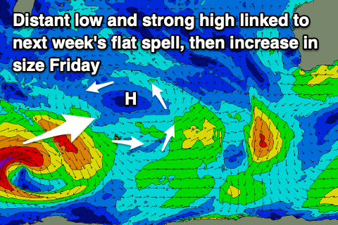
Unfortunately the rest of the outlook period is slow with fading surf thanks to a large blocking high moving slowly east through the Indian Ocean. This will prevent any major frontal systems firing up, but behind it a strong polar low should produce a new pulse of groundswell for next Friday.
The structure of the low isn't ideal for swell production, with instead of a drawn out fetch of W/SW winds being generated, we're looking at tighter, smaller fetch of W/SW gales. There's a change for severe-gales at the lows core, but it will break down quickly on approach to the Heard Island region.
This will produce a very inconsistent W/SW-SW groundswell that's due to arrive Friday and peak through the day to 4-5ft+ across the South West magnets, tiny to the north.
Winds unfortunately look to swing onshore next Friday from the W as a deepening mid-latitude low directly south of us, drifts south, opening up the region to its northern flank.
More on this Monday. Have a great weekend!


Comments
“Give it a miss if you’re not keen for a surf”
Kill me now.
Yep I’m getting sick of that copy & paste comment too!
Thirded
Me as well. Will let the reporter know.
I vote to keep it. Genuine highlight each day
My vote to keep as well. I like it.
Can we arrange for and decide this by poll, Craigos?
Haha, sorry already notified, hence the nice tune to today's.
Ha! Got to be quick around here
Check the photo on the Perth report, they would have to be kidding, can't call that surfing.
It is these days quokka
Craig it would be good to have a mention/incorporation of the tide in these outlooks. This past few days with the extreme low in the morning’s tide has probably been one of the biggest factors impacting surf quality & limiting options, but no mention of it in reports/forecasts.
No, if you can't figure it out for yourself you shouldn't be surfing hahahahaha, it's the same every year
Yeah I guess my comment was more a reflection on the fact that surf forecasts and reports talk at length about wind and swell with seemingly little attention to the interaction of tide & sand movement patterns. (I know the latter are hard to forecast and impacts are heavily spot-dependent).
Nailing the combination of swell, wind, tide & sand conditions would be the holy grail - could be a job for AI? Imagine knowing that the remote spot you’re trekking to based on forecast wind & swell - a spot that normally loves a high tide - is actually likely to be better on the low tide this time because of current unusual sand buildup?
Of course you could argue it takes away from the romance of simply having your local spot dialed, but that’s a different argument
https://tides.willyweather.com.au/wa/perth/perth.html