Small swells with windy conditions
Western Australian Surf Forecast by Craig Brokensha (issued Monday November 20th)
Best Days: Keen surfers tomorrow morning in the South West, similar Wednesday and then Friday, keen surfers Saturday afternoon
Features of the Forecast (tl;dr)
- Small mid-period SW swell building this afternoon, easing tomorrow, with a smaller reinforcing pulse for Wed
- Strong E/SE-SE tending S/SE winds tomorrow
- Strong E/SE tending S/SE winds Wed
- Strong E-E/NE tending variable winds ahead of late sea breezes Thu/Fri
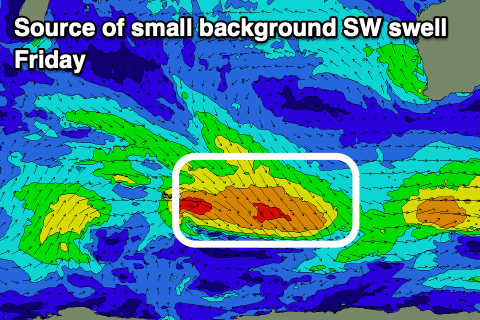
- Small mid-period SW swell for Fri
- Small S/SW groundswell building Sat, peaking in the PM with strong E/NE tending variable winds and late sea breezes
- Easing swell Sun with similar winds
- Small Mon with NE tending NW winds
Recap
Average surf on the weekend with a small to tiny start to Saturday, building through the day with a window of OK winds and swell before the sea breeze hit. While yesterday saw less than ideal winds as the swell held into the morning.
Today the swell is small again with SE winds, though some new energy is due through the afternoon but with strengthening S/SE winds.
This week and weekend (Nov 21 - 26)
Today’s building mid-period SW swell was generated by a healthy though not overly strong polar frontal system moving across the Heard Island region later last week.
It’s now on the build across the South West and should reach 4ft across the magnets, tiny to the north, easing from a similar size tomorrow morning, then down to 3ft+ on Wednesday.
Local winds will remain strong but tend E/SE-SE tomorrow morning across the South West, stronger S/SE into the afternoon.
Wednesday looks more offshore with strong E/SE winds but with the smaller 3ft or so of swell in the South West.

It might be worth trying to make the most of these small pulses as the rest of the week looks small and tricky with strong E-E/NE winds on Thursday morning, similar Friday along with another pulse of mid-period swell to 3ft max.
Moving into the weekend and a late forming low is due to fire up to the south-southwest of the state, late in our swell window again. This is the trend at the moment with nothing of significance south of the Indian Ocean and storms forming late, south of us before moving under the country.
The late formation will produce only a small pulse of swell, with a fetch of strong to gale-force winds due to generate a small kick in size Saturday afternoon to 4ft max in the South West, tiny to the north.

Winds look favourable most of the day, strong out of the E/NE, feeding into a heat trough to our north-west, similar Sunday as the swell fades.
The trough looks to shift south-east on Monday, bringing NE to NW winds but with no swell.
Longer term the outlook remains quiet and winds will revert back to the S/SE-S in the wake of the low on Monday. So all in all it remains slim pickings.

