Fun swell pulses with tricky winds for the South West
Western Australian Surf Forecast by Craig Brokensha (issued Monday October 9th)
Best Days: Wednesday morning Perth and Mandurah, protected spots afternoon in the South West, Thursday and Friday mornings, Saturday morning, Sunday morning
Features of the Forecast (tl;dr)
- Moderate-large sized mid-period SW swell building tomorrow, peaking Wed AM
- Gusty S/SW winds tomorow and Wed AM, shifting S/SE later (S/SE winds Perth and Mandurah each morning)
- Easing surf Thu with mod-fresh E/SE-SE tending strong S winds
- Moderate + sized W/SW groundswell Fri with mod-fresh E/SE-SE tending strong S winds
- Larger SW swell building Sat, peaking in the PM, easing Sun
- Strong SE tending S winds Sat, E tending SW winds Sun
Recap
The high-res wind model lost out on Saturday morning with favourable and improving conditions across the South West and a drop in swell from Friday coming in at 4-6ft. Conditions remain decent most of the day with fun, clean small waves to the north.
Yesterday deteriorated quickly as a trough moved through and this morning we've got lingering onshores and small, surf in the South West with 1-2ft waves across Perth and Mandurah.
This week and weekend (Oct 10 - 15)
Looking at the period ahead and we've got a fun swell with tricky but improving winds over the coming days, with a fun weekend of surf as a stronger groundswell fills in with offshore winds.
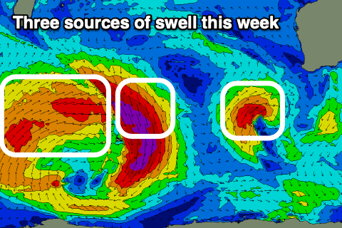
Firstly, the coming days swell is being generated by a small but strong low that's currently to the south-west of the state. A good, slow moving fetch of strong to at times gale-force SW winds are being generated, with the low weakening while moving east today and under us tomorrow.
This will bring gusty S/SW winds to the South West (S/SE to the north), unfortunately lingering into Wednesday but shifting S/SE later in the day.

Swell wise the surf should build into tomorrow afternoon but peak Wednesday morning with 6-8ft sets due in the South West, 2-3ft across Mandurah and 2ft in Perth.
The swell should start easing into Wednesday afternoon, with smaller, weaker 4-5ft+ waves due Thursday morning across the South West, 2ft Mandurah and 1-2ft Perth. Winds will swing E/SE-SE across the South West Thursday morning creating cleaner conditions ahead of strong S'ly sea breezes, similar Friday morning but with a new, moderate + sized groundswell.
This swell and a secondary pulse for Saturday afternoon are being generated by the same system, that being a strong, broad low firing up to the south-east of South Africa yesterday. At the head of the low, gale-force N/NW winds aimed towards the polar shelf will generate Friday's pulse of W/SW groundswell, while weaker but broader W/SW winds on the backside of the low look to generate an additional groundswell for Saturday afternoon.
Size wise, Friday's looks to come in at 4-6ft across the South West, 1-2ft to the north with Saturday's building to a stronger 6ft to occasionally 8ft in the South West into the afternoon, 2ft+ Mandurah and 2ft across Perth before easing Sunday.
Winds on Saturday looks to hold from the SE, fresh through the morning and strong S'th into the afternoon with Sunday looking better for exposed coasts as winds shift more E/SE-E in the morning.
Longer term there's not much to work with early next week so make the most of the coming windows of workable surf.

