Oversized swell on the build today with strong S winds
Western Australia Surf Forecast by Craig Brokensha (issued Wednesday August 2nd)
Best Days: Protected spots this afternoon and tomorrow, Friday, Saturday, Sunday morning, early Monday Perth and Mandurah, Wednesday morning
Features of the Forecast (tl;dr)
- Oversized SW groundswell building rapidly today with winds tending strong S-S/SW
- Easing swell tomorrow with gusty S/SE-SE tending S/SW-S winds in the South West, S/SE tending S/SE to the north
- Easing swell Fri with E/NE-NE tending light NW winds
- Building mid-period SW swell Sat PM, with a larger SW groundswell Sun with E/NE-NE tending light N winds Sat, E/NE tending weak sea breeze Sun
- Building, large mid-period W/SW swell Mon, easing Tue with N/NW winds in the South West Mon (NE early Perth and Mandurah), strong NW tending W/NW Tue
- Easing surf Wed with light offshore winds ahead of sea breezes
Recap
Clean conditions across Perth and fun 2ft waves yesterday, a little wind affected and to 2-3ft in Mandurah while Margs was poor and onshore.
This morning conditions are deteriorating across all locations as a trough brings strengthening N/NW winds ahead of a S-S/SW change along with an oversized, building SW groundswell.

Building sets with S'ly winds in the South West
This week and weekend (Aug 1 - 6)
Today's building groundswell was generated by a severe but slightly poorly aligned low that formed south-west of us on Monday. A great fetch of storm-force S/SW winds were projected towards Indonesia, with the low since weakening and broadening while moving east.

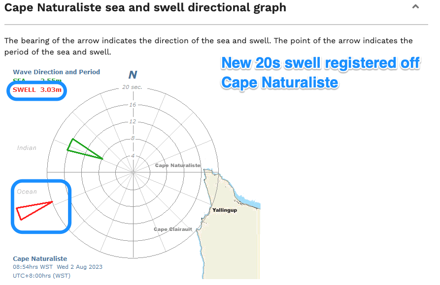
We should see oversized amounts of SW groundswell spreading into us, building rapidly today, with it just hitting the Cape Naturaliste buoy.
The South West should build to 12ft+ on the exposed reefs, easing from a similar size tomorrow morning, 3-4ft across Mandurah and 3ft in Perth.
Winds have already gone S'th across the South West, favouring protected spots and tomorrow morning we should see more favourable, fresh to strong from the S/SE-SE for a period before easing and tending more S-S/SW.
To the north gusty but easing S/SE winds look to shift S/SW through the day.
The swell will continue to ease into Friday with early E/NE-NE winds due to swing N and then NW through the day but without much strength.
Easing surf from 6-8ft is due across the South West magnets with 2-3ft sets in Mandurah, 2ft across Perth.
Into the weekend a new pulse of SW-S/SW groundswell is due to arrive later Saturday but peak Sunday, generated by a strong polar low forming east of the Heard Island region tomorrow. A fetch of W'ly gales should a good 6-8ft of groundswell for Sunday in the South West, 2-3ft in Mandurah and 2ft across Perth
Winds on Saturday ahead of the swell look similar to Friday, E/NE-NE early before going more N and then variable into the afternoon as some size shows late, with Sunday seeing E/NE offshore winds ahead of weak sea breezes.
Conditions will deteriorate as the swell eases into Monday with a freshening N/NW breeze in the South West, NE early to the north but small.

Some reinforcing, large, mid-period W/SW swell is expected to fill in on Monday, peaking into the afternoon and then easing Tuesday.
This will be generated by a healthy but not overly strong frontal progression pushing up across the Heard Island region tomorrow and Friday before weakening Saturday.
The size looks to be similar to that of Sunday's but weaker in nature and with those less favourable winds as stated above, strong NW-W/NW on Tuesday as it eases.
Light offshore winds look likely Wednesday as the swell eases, but more on this Friday. Beyond this the outlook is a little quiet but check back Friday for the latest update.

