Large swell peaking now, easing but offshore
Western Australia Surf Forecast by Craig Brokensha (issued Monday May 15th)
Best Days: Every day this period in the South West, Perth and Mandurah today and tomorrow
Features of the Forecast (tl;dr)
- Large, easing SW groundswell tomorrow with E/SE tending variable winds
- Smaller Wed with E/SE winds ahead of late sea breezes
- Building, inconsistent W/SW swell Thu PM with E-E/NE winds, easing Fri with similar winds
- New inconsistent SW groundswell for later Fri, peaking early Sat, easing through the day
- Fresh E/NE winds Sat, stronger E/NE Sun
Recap
Average surf on Saturday with onshore winds in the South West, cleaner to the north and small, better across all locations yesterday with a moderate sized swell and morning offshore winds.
Today a large new SW groundswell has filled in with clean conditions and building surf that's now 8ft+ in the South West, 2-3ft across Mandurah and 2ft in Perth. Light winds this afternoon should keep conditions favourable into the evening.

Large surf this afternoon
This week and weekend (May 16 - 21)
The large surf that's now peaking across the South West is due to start easing through tomorrow, down further Wednesday and Thursday morning.
Conditions look great with light E/SE offshore winds tomorrow morning that will tend variable into the afternoon along with easing sets from 6ft to occasionally 8ft in the South West, 2-3ft in Mandurah and 2ft across Perth.
Wednesday will become smaller and be dropping from 4-5ft on the sets in the South West, tiny across Perth with fading 1-2ft sets max in Mandurah. Conditions look great again though with offshore E'ly winds ahead of late sea breezes.

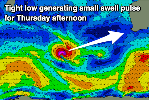
A temporary low point in swell is due on Thursday morning before a small to moderate sized W/SW swell kicks a little in the South West.
This has been generated by a tight, small low that's formed north of the Heard Island region, with a fetch of strong to gale-force W/SW winds due to kick the size back to 4-5ft+ into the afternoon across the South West, 1-2ft in Mandurah and 1-1.5ft across Perth before easing Friday.
Winds look great and offshore all day from the E-E/NE on Thursday, similar Friday as the swell eases.
Now, later Friday the next pulse of groundswell is expected, with a peak due on Saturday.
This has been generated by a distant, strong polar storm to the south of South Africa on the weekend, with it being inconsistent but decent in size, pushing to 6ft+ across the South West overnight Friday, then easing slowly from this size at dawn Saturday.
The size for Perth and Mandurah looks minimal with slow 1-1.5ft sets on the former and 1-2ft sets on the latter.
Favourable offshore winds will continue, lasting all day Saturday with Sunday seeing stronger E/NE winds as the size slowly eases.
Longer term there's nothing too major on the cards, but we should see a fun swell into Wednesday with possible light winds. More on this Wednesday.

