Improving surf from later tomorrow
Western Australia Surf Forecast by Craig Brokensha (issued Wednesday April 26th)
Best Days: Later tomorrow in protected spots, Friday, Saturday morning, Sunday ahead of the shallow change in the South West, Monday morning in the South West and Mandurah, Tuesday morning
Features of the Forecast (tl;dr)
- Temp low point in swell tomorrow AM ahead of a mix of mod-large building S/SW swells for the PM
- Early S/SW tending S/SE winds in the South West tomorrow, gusty W/SW tending S/SE by late AM to the north
- Peak in S/SW groundswell and mid-period energy Fri AM, easing
- Light-mod SE tending E/SE winds Fri AM, fresher S/SE into the PM
- Easing mix of swells Sat with E/NE-NE tending SW winds
- Building SW groundswells Sun, peaking in the PM with E tending weak S/SW winds
- Easing swell Mon with SE tending S/SW winds
- Good new swell Tue with E/SE tending S/SW winds
Recap
The South West has been large and stormy the past couple of days, easing in size today while Perth and Mandurah saw early windows of light winds yesterday morning before the onshore change moved through. Mandurah was 3ft while Perth offered 2-3ft waves.
This morning winds were a little weaker and S/SW, providing workable options for the keen across Mandurah to 2-3ft, choppy and to 2ft+ across Perth.
This week and weekend (Apr 27 - 30)
Looking at the end of the week, and the mid-latitude low that's been sitting off our south-west is now starting to push east, though an approaching polar front will push up and clip us, bringing initial poor conditions that will improve through the day tomorrow.
Early onshore S/SW winds in the South West and W/SW to the north are due to shift S/SE through the morning (starting first in the South West and then migrating north thereafter).
This will create improving conditions through the day and swell wise, we'll see the current energy easing temporarily ahead of a new mix of mid-period and stronger groundswell building through the afternoon. The South West isn't likely to drop below 4-6ft with 2ft sets to the north, building back later in the South West to 6-8ft.

Now, a peak in S/SW mid-period and groundswell energy is due early Friday, with the source being a strong polar low that formed around the Heard Island region earlier this week.
A fetch of W/SW gales was generated through our southern swell window, with the remnants of the storm projecting up and into us tomorrow, though in a much weaker form.
The models are mixing both swells together, over-forecasting the raw open ocean swell size and we can expect surf to 8ft+ on the South West magnets Friday morning, 2ft+ across Mandurah and 2ft in Perth before easing through the day.
A high will quickly move in behind tomorrow morning's change, bringing those S/SE winds, with Friday due to see better, light to moderate SE tending E/SE winds through the morning, back to the S/SE through the afternoon.

There'll still be plenty of lump in the surf during the morning, best just before winds tend back to the south.
Saturday will be clean and fun with an E/NE-NE offshore in the South West ahead of weak SW sea breezes, E/SE tending fresher S/SW to the north. The mix of swells will ease further and be dropping from the 6ft range in the South West and 2ft on the sets to the north.
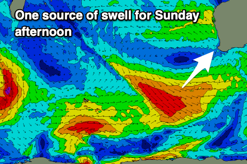
Come Sunday morning, we've got a very temporary low point in swell ahead of a mix of new SW groundswells arriving during the morning, peaking into the afternoon.
The source of the first will be a good fetch of pre-frontal NW tending W/NW gales tracking east-southeast through our swell window tomorrow, weakening on Friday. A secondary longer-period swell will be generated by gale to severe-gale NW winds that are currently west of Heard Island, but being aimed down towards the polar shelf while weakening.
Building sets to 6ft+ are due into the afternoon across the South West, with Mandurah being small and to 1-2ft, 1-1.5ft across Perth.
Winds look great and light offshore out of the E/SE before a trough brings a shallow S/SW change into the afternoon. There should be plenty of time for a quality surf before conditions become bumpy though.
Monday should be fun again but with morning SE winds as the swell eases back from a similar size to Sunday afternoon.
Longer term, besides another fun pulse of reinforcing mid-period S/SW swell thanks to trailing frontal activity behind the W/NW fetch, smaller surf is due through the week with favourable morning winds. More on this Friday.

