Poor surf until late week
Western Australia Surf Forecast by Craig Brokensha (issued Monday April 24th)
Best Days: Keen surfers early tomorrow Perth and Mandurah, Friday, Saturday, Sunday morning, Monday morning
Features of the Forecast (tl;dr)
- Large S'ly swell tomorrow in the South West, with smaller mid-period SW swell in metro locations
- Strong SW winds in the South West, variable for a period early in Perth and Mandurah
- Easing large mix of swells Wed with strong SW winds, shifting S/SW-S on Thu
- Temp improving winds to the S/SE in Perth and Mandurah late AM Thu and then S/SW into the PM
- Mod-large mix of building S/SW-SW swell later Thu, peaking Fri with moderate E/SE-SE tending stronger S/SE winds
- Easing surf Sat with moderate E/NE tending variable winds
Recap
Saturday's mix of mid-period SW swell and long-range W/SW groundswell filled in nicely across the South West with clean conditions and 6-8ft sets, 2ft in Mandurah and 1-2ft across Perth.
The swell started to ease slowly through yesterday and light, morning winds offered plenty of options before an approaching frontal system brought freshening onshore breezes into the afternoon.
Today is poor across all locations with a mix of building swells under gusty SW winds.
This week and weekend (Apr 25 - 30)
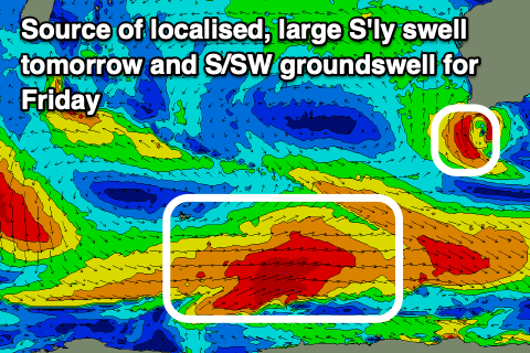
Settle in for a few days of poor conditions and average surf thanks to yesterday's cold front spawning into a strong mid-latitude low directly off the South West. This low will stall and direct gale-force S'ly winds up and into the tip of the state today, weakening slowly tomorrow and then pushing east, across us into the evening.
This will result in a poor run of winds and conditions across the South West thanks to strengthening SW winds tomorrow, easing a touch Wednesday but persisting from the SW and shifting S/SW-S on Thursday.
Perth and Mandurah should see a period of variable winds tomorrow and swell wise, there'll be a large S'ly groundswell pushing up the coast thanks to the gale-force fetch around the low, but this will be much smaller in the metro regions. Instead background levels of SW swell mixed in with the S'ly energy should come in at 2-3ft across exposed breaks, smaller in southern corners while the South West sees stormy in the 10ft range.
All locations will be poor Wednesday as the mix of swells remains large early but starts to ease, smaller Thursday and back to 6ft+ or so in the South West, 2ft in Perth and Mandurah. Winds on Thursday will be poor early across metro locations but could swing S/SE through the late morning, offering improving conditions.

Now as touched on last update, into Thursday afternoon and Friday a mix of new S/SW groundswell and mid-period energy is due to fill in as winds improve.
The groundswell will be generated by a broad polar low firing up east of the Heard Island region this evening, with a good fetch of polar W/SW gales due to move slowly through our southern swell window. A weak front is then due to spawn off the back of this fetch. projecting up and into the south of the state on Thursday, bringing some additional mid-period swell energy to the mix.
Size wise, the groundswell will be inconsistent and likely to 8ft+ on the sets, but with the southerly direction, a little less consistent and not getting into all spots. Perth and Mandurah should see 2ft+ and 2ft waves respectively on Friday and winds are expected to swing moderate E/SE-SE during the morning and then stronger S/SE through the afternoon.
Saturday looks great as the swell eases with an E/NE tending variable breeze.
Into Sunday, a new SW groundswell is expected, generated by a good pre-frontal fetch of gale-force W/NW winds moving through our south-western swell window. It looks to build to 6ft or so and with early offshore winds ahead of a trough and S/SW change and possible larger swell Monday. More on this in Wednesday's update.

