Slower end to the week, great Saturday
Western Australia Surf Forecast by Craig Brokensha (issued Wednesday April 19th)
Best Days: Today ahead of sea breezes, tomorrow morning in the South West (keen Perth and Mandurah), Friday morning in the South West, Saturday, early Sunday Perth/Mandurah, Thursday next week
Features of the Forecast (tl;dr)
- Smaller, weaker, easing swell tomorrow with E/NE tending NE winds ahead of moderate N winds late AM, tending N/NW
- Low point in swell Fri AM ahead of new, building SW swell for the PM. Dawn E/NE winds, tending NE then giving into weak sea breezes
- Mod-large building W/SW groundswell Sat, peaking in the PM with mod-fresh E/SE winds ahead of weak sea breezes
- Easing swell Sun with light winds at dawn, quickly freshening from the S/SW during the morning, then tending W/SW. Longer window of light winds to the north
- Mod-large mid-period SW swell building Mon with strong S/SW winds, easing Tue with S/SE tending S/SW winds
- Smaller Wed with E/SE tending SW winds
- Large, long-period S/SW groundswell building Thu with E/SE tending S/SW winds, easing Fri with fresh E tending SW winds
Recap
Excellent surf the past two days across the South West, really good and fun to the north as a mix of large swells filled in yesterday under offshore winds. The South West saw strong, consistent 10ft surf with building waves to 3-4ft in Mandurah and 2-3ft across Perth into the afternoon.
This morning was still pumping and easing from 8-10ft in the South West, 3ft across Mandurah and a slower 2-3ft in Perth. Make the most of the current conditions before sea breezes kick in mid-afternoon.


Around the grounds the last two days
This week and next (Apr 20 - 28)
We've got smaller but fun surf due into the end of the week, with the current swell due to ease steadily dropping back from 4-6ft early tomorrow morning across the magnets in the South West, 1-2ft in Mandurah and Perth.
A moderate to fresh E/NE offshore will create clean conditions at dawn before tending N/NE during the morning and then N'ly late morning, N/NW into the afternoon. So surf before lunch.
A temporary low point in swell is still due dawn Friday, but some new, inconsistent mid-period SW swell should build into the afternoon ahead of a stronger, but also inconsistent W/SW groundswell on Saturday.
The mid-period swell has been generated by weak pre-frontal activity ahead of a strong but distant fetch of W'ly gales, linked to Saturday's swell. These gales were generated to the south and south-east of Madagascar before weakening around the Heard Island.
Building surf to 5-6ft is due in the South West through the afternoon Friday, 1-2ft in Perth and Mandurah while Saturday's swell should build to an inconsistent 6ft to occasionally 8ft through the afternoon (smaller in the morning). Perth and Mandurah should build to the 2ft range. Our possible additional pulse of close-range SW swell for Saturday morning has fallen by the way side as expected, with the strengthening frontal system forming too late in our swell window.
Lighter E/NE-NE winds are due Friday morning shifting light N late morning and light W/NW into the afternoon. This should create fun surf as the swell builds.
Saturday morning will be the best with the building groundswell and moderate to fresh E/SE winds ahead of weak afternoon sea breezes (possibly variable).
Sunday should provide plenty of size, easing from 6ft+ in the South West and 2ft to the north, but besides early variable winds at dawn, an approaching front will bring freshening S/SW tending W/SW winds from mid-morning in the South West, later morning to the north and NW tending SW.

This front will be attached to a 'flash in the pan' low, with a burst of strong SW winds due to be projected up and into us, generating a moderate-large mid-period SW swell for Monday but with strong S/SW winds.
It won't be the best quality and only reaching 8ft in the South West through the afternoon, 2-3ft later in Mandurah and 2ft across Perth.
The swell will then ease through Tuesday with cross-shore, fresh S/SE winds. Not ideal.
Wednesday looks cleaner but small and weak ahead of a much better, long-period S/SW groundswell on Thursday.

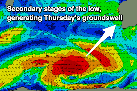
The source of this swell will be a strong polar low forming around the Heard Island region early next week, projecting a fetch of gale to severe-gale W/SW winds through our southern swell window.
The European version has a better looking low and projection, but regardless we should see sets building to 8ft+ in the South West, 2-3ft across Perth and 2ft in Mandurah.
Winds look offshore through the morning ahead of sea breezes Thursday, great on Friday as the swell eases, but we'll have a closer look at this Friday.

