Fun today and on the weekend to the south
Western Australia Surf Forecast by Craig Brokensha (issued Friday April 7th)
Best Days: Today and tomorrow morning in the South West, Sunday in the South West ahead of the NW winds, selected spots South West early Monday, Perth and Mandurah Friday morning next week
Features of the Forecast (tl;dr)
- Inconsistent SW swell filling in Fri, peaking through the day with gusty E/NE tending E/SE winds, S/SE-SE into the PM across the South West
- Easing surf Sat with gusty E/SE tending strong S/SE winds
- Building SW groundswell Sun with strong E/NE tending lighter NE then NW winds
- Easing SW groundswell Mon with strengthening N/NE tending N/NW winds
- Large SW groundswell Tue with strong W/SW-SW winds, easing Wed with strong W/NW winds
- Oversized swell Thu with strong W/SW-SW winds
- Easing swell Fri with strong S/SW winds in the South West, S/SE Perth and Mandurah through the morning
Recap
Clean conditions but easing surf from 2-3ft in the South West yesterday, tiny to the north.
Today a new swell is showing with clean conditions across all locations and sets to 4ft in the South West we should see the swell reaching 4-5ft+ as it peaks with 1ft to occasionally 2ft sets in Perth/Mandurah.
Winds look to remain favourable most of the day across most locations, tending more S/SE in the South West so surf before early afternoon down there.

New swell in the water this AM
This weekend and next week (Apr 8 - 14)
Today's new swell is expected to peak through the day and then ease through tomorrow with tiny waves in Perth and Mandurah, 4ft on the magnets in the South West along with E/SE tending strong S/SE winds.
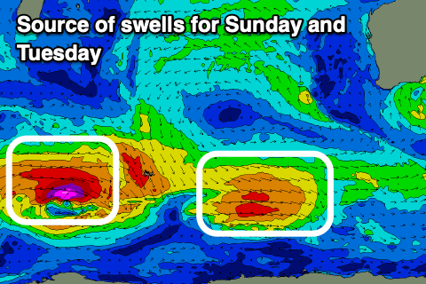
We may see a brief, low point in swell early Sunday ahead a new pulse of inconsistent SW groundswell that will peak through the afternoon.

This was generated by a small, tight low around the Heard Island region and should provide inconsistent 3-5ft sets across the South West magnets into the afternoon before easing Monday.
A better swell producer has formed behind the initial low, with similar strength gale to severe-gale winds generated but over a broader area.
This low will push towards us while weakening, with a mix of mid-period swell and groundswell due to arrive on dark Monday, peaking Tuesday to a good 6ft+ in the South West, 2ft across Mandurah and Perth.
Winds on Sunday will be good for most of the day and fresh from the E/NE, shifting NW mid-late afternoon with Monday seeing N/NE winds getting up early, shifting strong N/NW into the afternoon as a cold front approaches. This will unfortunately spoil Tuesday's swell with strong W/SW-SW winds due across most locations, shifting W/NW on Wednesday.

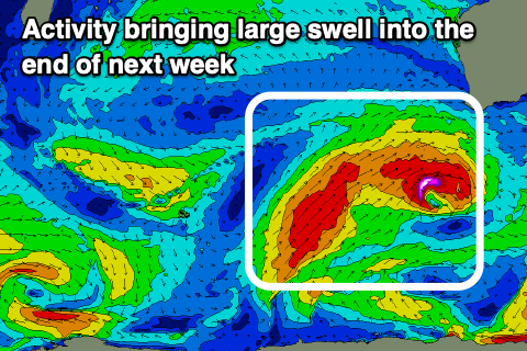
The frontal activity will be initially the remnants of Tuesday's swell producing storm, followed by a series of strong fronts pushing up and into us under the influence of a strong, stationary node of the Long Wave Trough.
Large surf is expected to develop later week but with strong W/SW tending SW winds Thursday, holding out of the S/SW on Friday. There's a chance for S/SE winds in Perth and Mandurah Friday morning along with surf in the 3ft range.
The frontal activity looks to continue but in a weakened form through next weekend, but we'll have a closer look at this Monday. Have a great weekend!

