Varying swell pulses with favourable winds
Western Australia Surf Forecast by Craig Brokensha (issued Wednesday April 5th)
Best Days: Friday all locations, Saturday morning in the South West, Sunday ahead of the late sea breeze in the South West, Monday in the South West, early Tuesday
Features of the Forecast (tl;dr)
- Easing surf tomorrow with E tending S/SW winds
- Inconsistent SW swell filling in Fri, peaking through the day with gusty E/NE tending E/SE winds, S/SE-SE into the PM across the South West
- Easing surf Sat with gusty E/SE tending S/SW winds
- Building SW groundswell Sun with gusty E/NE tending lighter NE then NW winds
- Easing SW groundswell Mon with gusty E/NE tending weaker N/NE winds
- Moderate sized SW groundswell for Tue with early E winds ahead of a SW change
- Large mix of swells building Wed with strengthening SW winds
Recap
Fairly average, wind affected conditions across the South West with an easing W/SW swell from Monday afternoon, cleaner in Perth and Mandurah but to 1-1.5ft.
Today the South West is poor with strong onshore winds, cleaner to the north but 1-1.5ft and peaky.

Raw surf yesterday AM
This week and next (Apr 6 - 14)
Looking at the coming days and tomorrow will become much cleaner across all locations with light E'ly offshore winds but a low point in swell. Try the South West magnets for 2-3ft leftovers.
We then look at our inconsistent SW swell for Friday, generated by a healthy but weakening low that formed south-southeast of Madagascar on the weekend.
The South West should see good 4-5ft+ sets as the swell peaks through the day (possibly a touch undersized at dawn) and 1ft to occasionally 2ft in Perth and Mandurah.
Conditions will clean again with an E/NE tending E/SE breeze in the South West ahead of stronger S/SE-SE winds into the afternoon as an inland trough starts to deepen. This should keep Perth and Mandurah clean all day.
The swell should ease into the weekend with fresh E/SE offshore winds favouring the South West along with easing 4ft sets on the magnets.
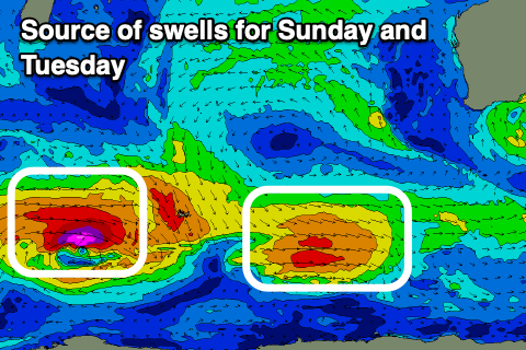
A temporary low point in swell may be seen early Sunday ahead of a new, building SW groundswell (peaking into the afternoon) and stronger pulse Tuesday.

These two swells will and are being generated by back to back polar fronts/lows firing up in the Heard Island region.
The first is smallest, with a fetch of gale to severe-gale W/NW winds due to generate Sunday's swell to an inconsistent 3-5ft in the South West through the afternoon, easing Monday.
The second system will be similar in strength but broader, weakening while slowly pushing east-northeast towards us through the weekend.
The swell from this low should arrive later Monday but peak Tuesday to 5-6ft in the South West with tiny 1ft to occasionally 2ft waves across Perth and Mandurah.
Winds on Sunday will be favourable most of the day and fresh from the E/NE, shifting more NE into the afternoon and easing ahead of weak NW sea breezes.

Monday looks to play out similar with gusty E/NE tending lighter N winds while early offshore winds on Tuesday are due to give into a SW change as the first in a series of strong cold fronts pushes up and towards us.
The current forecast updates have an initial strong polar low being taken over by a weaker, but broader front, projecting up and into us on Wednesday.
This will bring a mix of building windswell, mid-period energy and groundswell all amounting to surf in the 10ft+ range across the South West, 3ft in Mandurah and 2-3ft in Perth but with poor winds Wednesday, improving Thursday and Friday mornings if we're lucky. More on this Friday.

