Average couple of days, bigger next week
Western Australia Surf Forecast by Craig Brokensha (issued Wednesday March 8th)
Best Days: Saturday morning on the magnets across exposed breaks, Tuesday morning Perth and Mandurah, Wednesday morning all locations
Features of the Forecast (tl;dr)
- Swell bottoming out tomrorow and Fri
- Small, background SW swell Sat with E/SE-SE tending S/SW winds
- Easing surf Sun with developing onshore winds
- Building mid-period swell during Mon with early SE winds, peaking Tue with light W/SW-SW winds in the South West, S/SE to the north
- Easing swell Wed with variable tending SW winds
Recap
Our better pulse of S/SW swell for yesterday provided fun waves across the South West with clean conditions and surf in the 4-5ft range. Perth and Mandurah were clean but tiny and to 1ft.
This morning the swell has backed off with stronger offshore winds. The South West is offering 3ft leftovers for the keen.

Good sets yesterday
This week and next (Mar 9 - 17)
We're looking at a couple of lay days to end off the week, with the swell due to bottom out tomorrow and Friday and a trough will bring funky winds from about dawn tomorrow, swinging back offshore from the SE on Friday morning.
On Saturday, a small, inconsistent background swell should produce a small bump in size to 3ft+ across the swell magnets in the South West along with a light E/SE-SE morning breeze.
This swell will ease Sunday and another trough will bring dicey winds, light early, and freshening from the SW through the day.

Heading into next week, we've a bit of swell on the cards but the frontal progression linked to it will arrive with the swell, bringing average winds.
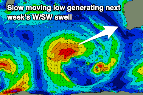
The source of the swell will be a strengthening polar front around the Heard Island region tomorrow, with it projecting slowly east-northeast towards us while generating a fetch of strong to sub-gale-force W/SW winds.
A moderate-large, mid-period W/SW swell is expected, arriving later Monday but peaking Tuesday, while a secondary intensification of S/SW winds more in our southern swell window should generate a reinforcing pulse for later week.
Tuesday's swell should peak to 6-8ft across the South West, 2-3ft in Mandurah and 2ft in Perth along with light W/SW-SW winds as the remnants of the front clips us. Perth and Mandurah should be cleaner with S/SE breezes in the morning, while Wednesday looks better with morning variable winds as the swell eases.
Longer term the frontal activity is a little patchy but we're looking at small to moderate sized swell pulses with better winds from later next week. More on this Friday.

