Poor outlook after a great little stint
Western Australia Surf Forecast by Craig Brokensha (issued Monday February 27th)
Best Days: Selected spots in the South West tomorrow morning, Friday morning South West magnets
Features of the Forecast (tl;dr)
- Easing surf over the coming days with strong SE winds tomorrow morning, strong E/SE Wed AM
- Low point in swell Thu AM with moderate E/SE winds in the AM
- Small mid-period S/SW swell Fri with light E/NE winds ahead of sea breezes
- S'ly winds Sat/Sun with small mid-period S/SW swell
Recap
Great conditions each morning across the South West, with a drop in swell from Friday, though still 4-5ft Saturday, with a reinforcing pulse of S/SW groundswell arriving through yesterday. Perth and Mandurah offered the most size Saturday morning, with tiny waves yesterday.
This morning conditions are still favourable but not as perfect as the weekend, with fun 4-5ft sets on the South West magnets, tiny to the north.

Wind getting into the swell later this AM
This week and weekend (Feb 28 – Mar 5)
Down, down, down.
That's the trend over the coming days, with the great run of surf and conditions seen since Friday due to come to a slow end.
Conditions will be a touch dicey tomorrow with a gusty SE breeze and easing S/SW swell energy from the 4ft+ range across the South West, tiny to the north.
Straighter, but still strong E/SE winds are due on Wednesday but with smaller, fading surf from 2ft to possibly 3ft on the small wave spots.

Thursday marks a low point in swell and winds will ease a little, moderate from the E/SE.
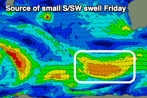
Friday should be nice and clean again and a small pulse of new mid-period S/SW swell is due, generated by a weak, pre-frontal fetch of W/NW winds moving through our swell window this evening and early tomorrow.
No major size is expected but a small bump to 3ft+ should be seen on the South West magnets under a favourable E/NE breeze. A trough will bring an overnight change, with poor S'ly winds due to dominate the weekend in its wake.
Swell wise, there's nothing major due, with the storm track being focussed away from us. Weak fronts are forming south-east of the Heard Island region, strengthening while projecting up and towards Tasmania, which is way too far east of our swell windows.
This will result in small to moderate sized mid-period S/SW swell pulses through next week with winds from the south-eastern quadrant. More on this in Wednesday and Thursday's updates.


Comments
For better or worse it seems WA has well and truly bounced back from our border closures.