Large easing surf, settling into a spring pattern
Western Australia Surf Forecast by Craig Brokensha (issued Monday 17th September)
Best Days: Tuesday and Wednesday mornings all locations, Thursday morning swell magnets in the South West, similar Friday, Saturday and Sunday swell magnets in the South West
Recap
Pumping large clean surf across the South West Saturday (pictured below thanks to Peter Jovic) with favourable winds most of the day, 3ft and clean around Mandurah and 2-3ft in Perth.
The swell was half the size into Sunday with early light variable winds.
Today another large and powerful SW groundswell is on the build across the state, generated by a very deep and intense polar low over the weekend. Conditions are best in protected spots though with gusty S/SW winds.

Today’s Forecaster Notes are brought to you by Rip Curl
This week and weekend (Sep 18 - 23)
This afternoon's increase in oversized long-period SW groundswell is expected to peak later today/this evening and then ease off through tomorrow as winds try to improve.
We're due to see a S-S/SE breeze across the South West with easing sets from the 10ft range, cleaner to the north with E/SE winds and easing sets from 3ft in Mandurah, 2ft to possibly 3ft in Perth.
Wednesday will be smaller again with similar winds, though more variable across the South West.
 Size wise, Margs will be smaller and dropping from the 6ft range, 2ft in Mandurah and 1-2ft Perth.
There's not much on the cards for the rest of the week besides small SW groundswell energy spreading radially up and into us from less than favourably aligned pre-frontal W/NW-NW fetches.
The best pulse looks to build Thursday afternoon and peak Friday morning to 3-5ft across Margs, tiny to the north.
Winds Thursday morning look favourable for swell magnets with an early E/NE breeze, tending NW with an approaching trough, with Friday seeing variable breezes as the trough passes.
This will likely leave a bit of lump and wobble on the coast, with better offshore E'ly winds Saturday as the swell eases from 3-4ft on the magnets.
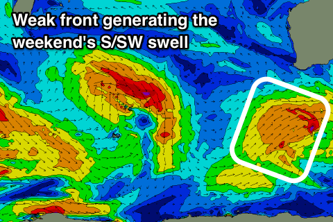
Longer term there's nothing too significant with a broad but relatively weak polar front forming south-west of us late week due to generate a small spike of mid-period S/SW swell for the afternoon, easing Sunday.
Winds look offshore all day Saturday as the swell builds, reaching 4-5ft across the South West, tiny to the north, then easing from the 4ft range Sunday morning with E'ly offshores again.
Longer term the outlook remains quiet with no major swells on the cards until possibly later next week. More on this Wednesday.

