Slow improvement in conditions as the swell drops
Western Australia Surf Forecast by Craig Brokensha (issued Wednesday 29th August)
Best Days: Perth and Mandurah Friday morning, all locations Saturday morning, Margs magnets Sunday and Monday morning
Recap
A small window of OK winds across the South West yesterday morning before swinging onshore along with the rest of the coast, followed by a mix of building NW windswell and SW groundswell.
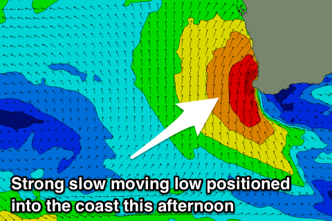
The lows axis remained east of us bringing a window of offshore winds this morning as expected, but the size of the W/NW swell was much bigger than anticipated. Perth saw epic clean 3-4ft surf, similar in Mandurah while early light winds around Margs quickly gave into an onshore change.
The low has since started moving inland bringing onshore winds to all coasts and an abrupt end to the pumping surf.
Today’s Forecaster Notes are brought to you by Rip Curl
This week and weekend (Aug 30 – Sep 2)
With the intense mid-latitude moving across us today, we'll see a fetch of S/SW gales pushing into and across all locations this afternoon, resulting in a drop in W/NW swell and late increase in stormy S/SW swell.
 The low will continue to weaken while moving slowly east through tomorrow, keeping strong onshore S/SW winds blowing across all locations as the S/SW swell eases from a stormy 8ft across the South West, 3-4ft in Mandurah and Perth.
Friday morning will be smaller again and weak, ahead of a new SW groundswell building through the day.
This distant groundswell isn't due to offer any major size, with magnets in the South West expected to reach 6ft into the afternoon, with 2ft waves around Mandurah and 1-2ft sets in Perth.
Conditions will be better through the morning ahead of the swell in Mandurah and Perth with an E/SE offshore, while Margs looks to linger onshore out of the S/SW-SW.
Saturday finally looks cleaner with a light E/SE offshore across all locations and easing SW groundswell from an inconsistent 4-6ft across the South West, 2ft in Mandurah and 1-2ft in Perth.
Sunday will be best across the South West as the swell continues to ease leaving tiny waves to the north along with an E/NE offshore. A new S/SW groundswell should be in the water, generated by a late forming polar low to our south tomorrow evening.
No major size is expected, with sets to 3-4ft across magnets, similar to background SW energy.
Next week onwards (Sep 3 onwards)
A low point in swell with early variable winds ahead of an increasing W/NW breeze is due Monday, poor Tuesday with a continuation of onshore winds.
This onshore wind will be linked to a slow moving and strong polar front pushing up and towards us from the weekend through early next week.
The storm will actually develop south-east of South Africa and slowly move towards us, generating a large and powerful W/SW groundswell building later Tuesday and peaking Wednesday.
Unfortunately winds look onshore due to the slow moving nature of the remnants of the storm, bringing strong S/SW winds Wednesday, more W/SW as the swell eases due to another approaching front.
There doesn't look to be any respite until the swell fades, but more on this Friday.

