Easing surf, with a fun swell Thursday
Western Australia Surf Forecast by Craig Brokensha (issued Monday 18th December)
Best Days: Swell magnets Wednesday morning across the South West, Thursday morning
Recap
Super fun waves across the South West Saturday morning with clean 3-4ft sets ahead of a strengthening onshore change late morning and more so into the afternoon. Further north conditions were also clean but the surf tiny.
Into yesterday we saw strengthening onshore winds and deteriorating weather with a building mix of windswell and groundswell. This morning we've got easing stormy surf from 10ft+ across the South West 3-4ft in Mandurah and 3ft+ up around Perth.
Today’s Forecaster Notes are brought to you by Rip Curl
This week and weekend (Dec 19 - 24)
The strong and powerful low responsible for our current weather and large stormy surf is now weakening, but we still saw a fetch of S/SW gales aimed in our southern swell window this morning.
We'll see the surf easing while tending S/SW in direction tomorrow, though winds will remain poor and onshore from the S/SW across all locations, tending more S through the day across the South West.
Protected spots won't be great due to the S/SW swell direction and we're only looking at easing surf from the 6ft to possibly 8ft range across the exposed reefs, with easing 2-3ft surf further north.
Wednesday is looking great condition wise with a straight offshore wind, but as talked about last Friday, there'll be no size left at all.
 Margs will only be around 2-3ft max at swell magnets, and 0.5-1ft further north, if that.
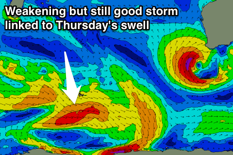
Later in the day Wednesday and more so Thursday, a new long-period SW groundswell is due, produced by strong low turned front that was strongest south-east of South Africa before dipping east-southeast towards Heard Island and weakening.
An inconsistent long-range swell should build through later Wednesday and peak Thursday to 4-5ft+ across swell magnets, with tiny 1-1.5ft surf around Mandurah and 1ft+ Perth.
Winds look as if they'll tend a little more SE Thursday morning, but be favourable while average and fresh to strong S/SE winds are expected Friday as a strong high moves in from the west and the swell continues to ease.
This high will put a block across our main swell windows, with no significant swell generating storms due to develop close to us. We'll have to rely on long-range energy, and we should see some good long-period swell arriving mid-next week, though that's a while away.
Check back here Wednesday for more on this.

