Oversized swell for Sunday, cleanest to the north
Western Australia Surf Forecast by Craig Brokensha (issued Friday 24th June)
Best Days: Perth Sunday and early Monday, both coasts Thursday and Friday
Recap
Tuesday afternoon's kick in SW groundswell held well into yesterday morning across all coast but conditions were poor in the South West with a S/SW wind. Better conditions were seen to the north with morning offshores and weak sea breezes.
Today the swell was still fun and 1-2ft around Perth and Mandurah with workable 4-6ft waves in the South West. Winds have since swung more N'ly across the South West though, creating poor conditions.
This weekend (Jun 25 - 26)
Tomorrow will be a lay day with a SW change expected to move through around dawn, creating poor conditions across all locations with a smaller swell.
Late in the day some mid-period swell is due to build, ahead of a much larger, powerful and oversized SW groundswell Sunday.
 Satellite observations have confirmed a great fetch of 50kt SW winds being generated in our south-western swell window, with the low continuing to generate winds at this strength while projecting up towards us.
An oversized SW groundswell will be generated with a peak expected Sunday morning to 12-15ft in the South West with 15-20ft sets at offshore reefs and bommies. Perth should see 3-4ft sets.
Unfortunately conditions are looking poor in the South West with a W/NW wind developing around or shortly after dawn, freshening through the day. Perth and Mandurah will be better with E/NE offshores, tending N/NW into the afternoon.
Next week onwards (Jun 27 onwards)
Sunday's oversized SW swell will ease off into Sunday afternoon and further Monday as NW winds continue to create poor conditions across the South West. Perth should be better with a dawn NE'ly tending N'ly by mid-morning and with easing 2ft+ sets.
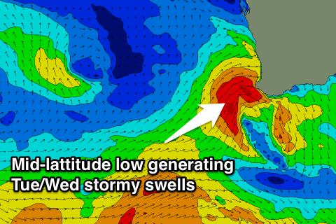
 Tuesday will be even smaller and a strengthening mid-latitude low pushing into us during the day will kick up a building W'ly swell later in the day, easing from the SW on the backside of the low.
A stormy 6-8ft of swell is likely later Tuesday and Wednesday morning across the South West with 2-3ft sets around Perth but with fresh to strong NW tending W'ly winds on the former and W/SW winds on the later.
Of greater importance is the development of a couple of vigorous polar frontal systems through our swell window next week.
The first one due Thursday will strengthen right in our doorstep, projecting a fetch of SW gales under the state.
A large consistent SW groundswell is due off this front, coming in at 8-10ft across the South West and 2-3ft in Perth. Offshore winds are due across Perth with this swell, and variable winds in the South West, creating OK conditions.
Another large SW groundswell is on the cards for Sunday week, but we'll review this again Monday. Have a great weekend!

