Small to moderate swell pulses with favourable winds
Western Australia Surf Forecast by Craig Brokensha (issued Wednesday 6th April)
Best Days: Swell magnets every day besides Saturday
Recap
Average conditions across the South West with a building S/SW swell yesterday, cleaning up later as winds tended more S/SE. Perth and Mandurah were tiny, and spiked a little late afternoon, but have eased back to a tiny 0.5ft today.
The South West was the best option with easing 3-4ft sets under offshore breezes.
This week and weekend (Apr 7 - 10)
The surf will continue to ease into tomorrow with great conditions under a morning offshore but fading 3ft sets across south swell magnets.
Into Friday a new SW groundswell should build through the day, small early, but reaching an inconsistent 3-4ft+ across exposed breaks through the middle of the day/afternoon.
This has been generated by a pre-frontal fetch of W/NW gales, ahead of an unfavourably tracking polar low, with the low due to aim a better fetch of SW gales through our southern swell window this afternoon/evening and into tomorrow morning.
A better S/SW groundswell will will spread up radially into the South West Saturday from this polar activity, peaking across exposed breaks in the 4-5ft+ range.
Secondary fetches of SW gales through our southern swell window tomorrow and Saturday morning, should produce some reinforcing S/SW swell for Sunday but more so Monday, keeping exposed breaks kicking around 4-5ft, with the odd bigger set possible Monday morning.
From here though the swell will ease and bottom out through the middle of the week in the 3ft+ range.
Perth and Mandurah aren't due to see any size from these S/SW pulses, with tiny 0.5-1ft sets max.
 Conditions are looking great Friday morning with an E/SE offshore again, strengthening from the S/SE into the afternoon.
Unfortunately fresh to strong SE winds Saturday morning are less than ideal, but from Sunday better offshores are due, swinging slowly anti-clockwise towards the E/NE Tuesday and then NE Wednesday as the swell gets smaller.
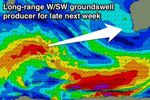
Longer term some long-range and inconsistent W/SW groundswell is on the cards for Friday, but only in the moderate size range. More on this Friday.

