Fun Wednesday, another similar swell for Saturday afternoon but onshore
Western Australia Surf Forecast by Craig Brokensha (issued Monday 4th January)
Best Days: Wednesday morning Margs and Perth, Thursday and Friday mornings Margs, Sunday protected spots Margs
Recap
Small clean waves for Saturday morning only suitable to exposed breaks in the South West, with a slight kick in size for the afternoon but with sea breezes. Tiny around Perth and unsurfable.
The swell dropped back into Sunday with less favourable SE winds around Margs.
Today another small pulse of SW groundswell has offered better 3ft to occasionally 4ft sets across the South West with morning offshores, but sea breezes are now in. Perth and Mandurah remained tiny and unsurfable.
This week (Jan 5 – 8)
Today's small kick in SW groundswell will ease back into tomorrow with less favourable and strong SE winds across the Margaret River region while Perth should see E'ly offshores but no real size.
Wednesday's inconsistent but good new SW groundswell is still on track, generated by a vigorous polar low tracking along the polar shelf from west of Heard Island.
Margs should see 5-6ft sets at swell magnets with Perth offering 1ft to occasionally 2ft sets, but with long waits between.
Conditions are looking great with moderate to fresh E/SE offshores around Margs and E/NE winds up in Perth ahead of afternoon sea breezes.
Thursday and Friday will be clean as the swell eases under E/NE winds, from 4-5ft or so around Margs on the former, small into Friday. Perth will be tiny.
This weekend onwards (Dec 9 onwards)
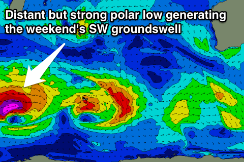
 Another very similar swell to Wednesday's is expected on Saturday afternoon, easing through Sunday, generated by another vigorous polar low firing up west of Heard Island.
A fetch of severe-gale to storm-force W/SW winds will be generated in our far swell window, with the low weakening once pushing east of Heard Island.
An inconsistent but good 5-6ft of SW groundswell is due into Saturday afternoon from this low, with Perth only kicking late to 1ft to possibly 2ft. Winds look to go onshore through Saturday though as a trough moves in from the west, with S/SE winds as the swell eases Sunday.
Longer term another inconsistent long-range W/SW groundswell is on the cards for the middle of next week, but more on this Wednesday.

