Large swell for Friday, best in protected spots, pumping and easing Saturday
Western Australia Surf Forecast by Craig Brokensha (issued Wednesday 23rd December)
Best Days: Friday protected spots, Saturday, Sunday morning, Tuesday and Wednesday mornings in protected spots
Recap
Small waves yesterday morning in the South West to a clean 2ft, building a touch more into the afternoon, while Perth and Mandurah remained flat.
Today a better long-period SW groundswell is filling in, with solid clean 5-6ft sets across exposed breaks in the South West this morning, 1-1.5ft up in Perth, with a further kick seen into this afternoon. Light sea breezes are keeping conditions workable in the South West and Perth.
This week and weekend (Dec 24 - 27)
Today's initial strong kick in SW groundswell should hold a similar size through tomorrow, if not a touch smaller with inconsistent 6-8ft sets across exposed breaks in the South West, with 2ft sets in Perth. Winds will unfortunately take a turn for the worse with fresh and gusty S/SW breezes due in the South West, and S'ly tending S/SW winds around Perth.
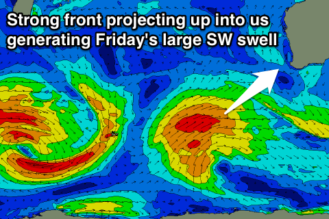
 This will be related to a strong front spawning off the polar low that was stalling to our south-west, aiming a fetch of SW gales right smack bang up into the south-west corner of the state.
This will produce a more consistent and secondary large SW groundswell for Friday to an easy 8ft, with 10ft bombs rolling through as the swell peaks.
Perth should kick to 2ft to occasionally 3ft through the day, with fresh and gusty morning SE winds, tending S/SW into the afternoon. Margs will see fresh to strong S/SE winds, favouring protected locations (which will be smaller).
Saturday is the day to surf as the SW swell eases from 6ft to possibly 8ft in the South West and 2ft in Perth under straight offshore E-E/NE winds.
Sunday will be smaller again with less favourable SE winds in the South West through the morning, straighter offshore from the E/NE around Perth.
Next week onwards (Dec 28 onwards)
Some fun new SW groundswell is due into next week, mainly Tuesday through Thursday across the region. This will be produced by relatively weak but persistent frontal activity through the Indian Ocean from tomorrow through the weekend and Monday.
Varying pulses of SW groundswell will be produced, the best through Tuesday afternoon/Wednesday to 5-6ft or so. Perth should see 1-2ft sets, and morning SE winds will favour semi-protected spots.

