Easing surf ahead of a good weekend swell
Western Australia Surf Forecast by Craig Brokensha (issued Wednesday 11th February)
Best Days: Thursday morning, Sunday morning, Monday morning, Wednesday morning
Recap
A good pulse of SW groundswell filled in yesterday but winds were less than ideal across most locations, best in protected locations. Today a stronger SW groundswell offered bigger 5-6ft waves in the South West under stiff offshores, 2ft sets in Perth and 4-5ft waves up at Gero.
Sea breezes are now starting to kick in across most locations, deteriorating conditions into this afternoon.
This week (Feb 12 - 13)
Tomorrow morning will be the best day running into the end of the week with a dropping swell from 3-5ft in the South West, 1-2ft in Perth and 3-4ft up at Gero under offshore E/SE winds around Margs and Perth, while Gero will see funky SE possibly tending E/NE winds through the late morning.
Friday will be smaller and early light winds are due to give way to an onshore S/SW change mid-late morning.

This weekend onwards (Feb 14 onwards)
The first of two good pulses of SW groundswell is still on track for Saturday afternoon/evening and Sunday morning, but Monday's secondary pulse has been downgraded and pushed back to Tuesday/Wednesday.
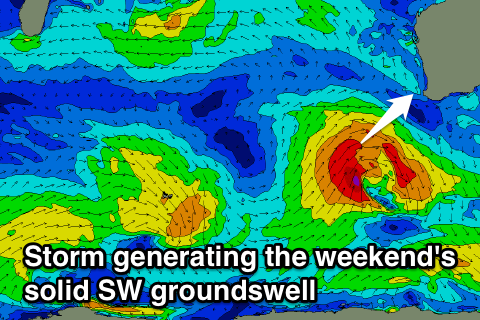
The first SW groundswell has been upgraded though, with a mid-latitude low expected to form south-west of us tomorrow, aiming a fetch of gale to severe-gale SW winds towards us through Friday before passing by overnight.
The swell isn't expected to be there at dawn Saturday but by lunchtime the Margs region should see it kicking, reaching a solid 6ft+ by dark, peaking overnight and easing from the 6ft range Sunday morning.
Perth probably won't see much size later, with easing 2ft+ waves Sunday morning, while Gero should see 4-5ft sets.
Conditions Saturday aren't looking great with a S/SE tending S/SW breeze but Sunday looks excellent with winds swinging offshore from the East across all locations. We'll have to confirm this Friday though, as the European model has less favourable SE breezes.
Monday will be smaller under SE winds, with the next pulse of groundswell arriving later Tuesday in the South West.
This SW groundswell will be a lot less consistent and a touch smaller than the weekend's, generated by a strong, broad and slow moving polar low over the weekend and Monday.
A fetch of strong to gale-force W/SW winds will be generated in our swell window, generating an inconsistent SW groundswell. Margs should peak in the 5-6ft range with the odd bigger bomb possible early Wednesday, with 2ft+ sets in Perth and 3-4ft+ waves up at Gero. Winds look to be generally from the SE but we'll review this Friday.

