Large and onshore tomorrow, clean but easing Monday
Western Australia Surf Forecast by Craig Brokensha (issued Friday 21st November)
Best Days: Monday morning all coasts, Tuesday and Wednesday mornings in the South West and up at Gero
 This weekend (Nov 22 - 23)
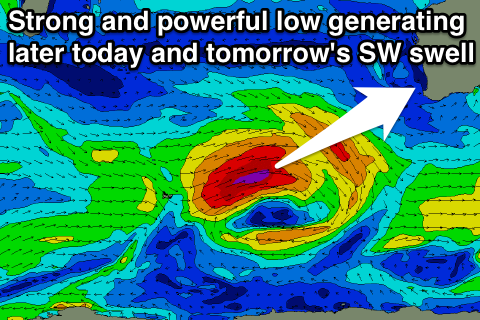
A very strong and powerful low pressure system position to our south-west towards Heard Island aimed a fetch of severe-gale W/SW winds towards us a couple of days ago. This low has since weakened and is passing under the state with a large and powerful SW groundswell due to fill in later this afternoon across the South West (arriving overnight further north and peaking tomorrow morning).
We should see the South West reaching 10ft later today ahead of a peak overnight, easing from the 8-10ft+ range tomorrow morning. Perth should ease from 3ft+ and Gero 6ft+.
Winds will unfortunately still be onshore in the wake of the system pushing across us today with SW winds across most spots, while a secondary weak system pushing into us Saturday evening will leave S/SW winds into Sunday as the swell continues to ease.
Next Monday onwards (Mon 24 onwards)
The front pushing up into us Saturday evening will produce a reinforcing S/SW swell for Sunday afternoon and this will slowly ease through Monday and further into the middle of the week as winds improve.
We should see clean easing surf from 4-6ft Monday in the South West, 2ft in Perth and 3-4ft up at Gero.
Tuesday should see better E/NE winds around Perth and Gero as E/SE winds persist around Margs, while as the swell bottoms out, hot E-NE winds will blow across most locations.
Unfortunately there's nothing too major on the cards into next week or the following weekend as a blocking high sets up across to our west and a deepening heat trough develops into a low during the end of the week.
This will cause winds to go funky from the NW, with only a couple of smaller sized long-range SW groundswells due.
Therefore make the most of Monday and Tuesday's waves across the state.

