Small windows Thu/Fri mornings, onshore weekend, clean from Tuesday
Western Australia Surf Forecast by Craig Brokensha (issued Wednesday 24th September)
Best Days: Thursday and Friday mornings around Perth and Gero, protected spots around Margs Monday and Gero through the morning, everywhere Tuesday and Wednesday
Recap
Perth and Gero offered fun waves yesterday morning while morning offshores and an easing swell the South West saw onshores. Today conditions were again poor in the South West, while Perth and Geraldton saw much better waves with light offshores again.
This week through Monday (Sep 25 - 29)
Unfortunately the coming few days are looking poor as a couple of strong frontal systems push up and into us bringing large amounts of swell but terrible winds.
An initial large long-period SW groundswell tomorrow will be spoilt by strengthening NW winds in the South West but Perth and Gero should see early offshores before going onshore into the afternoon.
The swell will back off a touch into Friday but strong onshore NW winds are expected to persist in the South West, with an early N/NE'ly around Perth and better NE winds up at Gero before also going NW into the afternoon.
Saturday will see the front move though with W/SW winds developing across all locations with a new large pulse of W/SW groundswell.
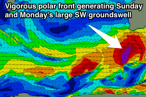
 The largest pulse is due on Sunday afternoon and Monday from the SW as a vigorous polar front pushes from east of Heard Island up towards the Bight while generating a fetch of severe-gale W/SW winds.
Winds will still be onshore as this swell builds Sunday though with strong but easing W'ly winds in the South West, and lighter S/SW winds up at Gero.
Monday will be slightly better but still annoyingly onshore with a lingering SW'ly in the South West, S/SW up at Perth but better and offshore from the E/SE around Gero with 5-6ft of swell.
The South West will be in the 8-10ft range and workable in protected locations with 3ft sets up in Perth.
Next Tuesday onwards (Sep 30 onwards)
Tuesday will be the day to surf across all locations with an easing SW swell from 6ft to occasionally 8ft in the South West, 2-3ft in Perth and 4-5ft up at Gero under offshore E/SE winds ahead of S/SE breezes into the afternoon.
Wednesday looks even better with straighter E/NE offshores as the swell continues to ease.
Longer term there's nothing too major on the cards until the following weekend when a moderate to large W/SW groundswell may arrive, but we'll look at this again on Friday.

