Pumping Friday, Sunday and Monday
Western Australia Surf Forecast by Craig Brokensha (issued Tuesday 29th July)
Best Days: Thursday, Friday, Saturday morning, Sunday, Monday
Recap
Geraldton has been the only place offering respite from the persistent onshore winds across the state with plenty of swell to boot. Lighter onshore winds opened up better conditions across Perth this morning, while Margs remained a mess.
This week (Jul 30 – Aug 1)
We've got one more day of onshore winds across the state, but from then we're looking at a great period of waves with plenty of swell and offshore winds.
The current progression of fronts across the southern half of the state will come to an end through tomorrow, as one final and vigorous polar front projected up towards us, clipping the south-west of the state before racing off quickly to the east.
With this we'll see a large SW groundswell created, filling in Thursday and peaking during the afternoon across the South West, Perth late in the day and Friday around Gero.
Exposed breaks around Margs should build to 10ft+ through the afternoon with 12ft bombs while Perth should build to 3ft+ late and Gero to 6ft+, peaking early Friday to 6ft to occasionally 8ft.
Winds as touched on will be onshore tomorrow and from the W/NW tending W/SW around Margs and Perth with light SE tending S/SW winds around Gero. Into Thursday as the large swell starts to kick winds should swing SE in the South West and E/SE further north, but Friday will be the day with the easing swell and offshore E/NE winds. A swing to the N/NE is due around Margs through the day, so surf through the morning for the best conditions.
This weekend onwards (Jul 2 onwards)
Thursday/Friday's swell will continue to bottom out into Saturday and winds will remain favourable for the most part with morning offshores that'll swing S/SE into the afternoon.
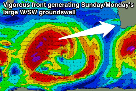
 Into Sunday afternoon and Monday another large W/SW groundswell is due, produced through the Southern Indian Ocean by a very broad and strong couple of cold fronts. An initial fetch of severe-gale SW winds south-east of South Africa will set up an active sea state for a much broader and stronger frontal system to generate an additional fetch of severe-gale W/SW winds over.
This will produce a large and powerful W/SW groundswell, arriving strongly Sunday and building to a large 10-12ft in the South West late in the day, 3-4ft in Perth and 6-8ft around Gero by dark.
Monday morning should will only be a touch smaller than later Sunday ahead of a gradual drop in size through the afternoon and further Tuesday and Wednesday.
Winds look excellent for this swell, with an offshore E/NE tending variable breeze on Sunday and similar E'ly tending variable winds Monday. Winds will likely swing more N'ly as the swell backs off into the middle of the week, but we'll confirm this tomorrow.

