Large swell easing with improving winds ahead of a new pulse Thursday/Friday
Western Australia Surf Forecast by Craig Brokensha (issued Monday 28th of April)
Best Days: Tuesday morning in Perth and Gero, Wednesday morning, Friday morning, Saturday morning, Sunday morning
Recap
Saturday saw small clean fun waves across exposed spots around the state while an onshore change moved through yesterday writing off the surf across most spots.
Today a large SW groundswell has moved in behind the front, building to a messy 10ft+ or so across exposed spots in the South West with fresh SW winds, while Mandurah saw early S/SE winds and 3ft+ of swell and Perth came in the with plenty of size but poor onshores similar to Margs. Geraldton was also solid but onshore with protected breaks fairing the best.
This week (Apr 28 – May 2)
Today's large pulse of SW groundswell is expected to peak this afternoon and ease gradually through tomorrow and further Wednesday. Winds will linger from the S/SW tomorrow around Margs, keeping conditions below par, while Perth and Gero should see more favourable E/SE offshores.
Wednesday will be better down in the South West with a variable breeze that should slowly increase from the SW.
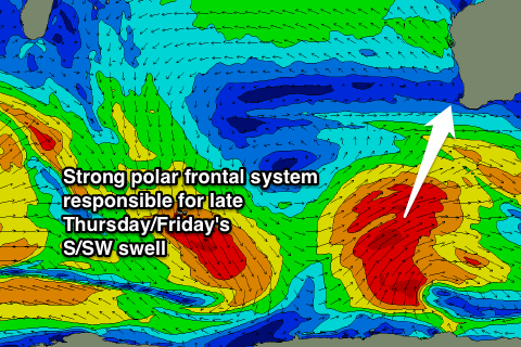
As touched on late last week, a couple of large S/SW groundswells are due into Thursday and Friday, generated by a couple of strong polar fronts firing up to our south-west over the coming days. The first long-period but only medium sized swell is being generated by a right but intense polar low and should arrive through Thursday and peak into the afternoon.
 A larger increase will arrive later Thursday and peak overnight, generated by a secondary much broader but weaker polar front firing up on the tail of the right low, aiming a fetch of SW gales up towards the Bight, in our southern swell window (pictured right).
Size wise, the South West should build to 6-8ft by dark Thursday and ease from a similar size Friday while Perth is only due to reach 2ft and ease from 2ft to possibly 3ft Friday morning. A peak Friday morning to 4-6ft is due in Gero.
Winds as the swell builds are expected to be fresh from the S/SE in Margs and Perth, with SE winds around Gero, while Friday looks great with E/SE winds across most regions (possibly still SE around Margs).
This weekend onwards (May 3 onwards)
Longer term there's nothing too major on the cards besides medium levels of SW groundswell. We'll review this and the winds for Friday morning again on Wednesday.

